Engel’s geodata
Engel’s (Saratovskaya Oblast) is a populated place; located in Russia in Europe/Saratov (GMT+4) time zone. With population of 196,011 people, there are 102 cities with bigger population in this country. Compared to other cities in Russia, 72.7% of cities are located further ↑North; 53% of cities are located further ←West and 95.2% of cities have higher elevation than Engel’s. Note1


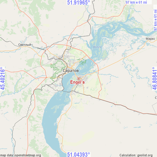
Engel’s GPS coordinates[2]
51° 29' 2.004" North, 46° 6' 19.008" East
| Map corner | latitude | longitude |
|---|---|---|
| Upper-left | 51.91965°, | 45.40216° |
| Center: | 51.48389°, | 46.10528° |
| Lower-right: | 51.04393°, | 46.80841° |
| Map W x H: | 97.4×97.4 km | = 60.5×60.5mi |
| max Lat: | 73.50819° ⇑72.7% North |
| Engel’s: | 51.48389° |
| min Lat: | ⇓27.3% South 41.28413° |
| min Long | Engel’s | max Long |
| -179.12198° | 46.10528° | 179.35046° |
| W 53%⇐ | ⇒47% E |
Elevation
Elevation of Engel’s is 12 m = 39 ft, and this is 190.6 m = 625 ft below average elevation for this country.
| Max E: |
2518 m = 8261 ft | 95.2% |
| Avg. | 202.6 m = 665 ft | |
| Engel’s | 12 m = 39 ft | |
Min E: |
-28 m = -92 ft | 4.8% |
See also: Engel’s elevation on elevation.city.
Geographical zone
Engel’s is located in North temperate zone (between Tropic of Cancer and the Arctic Circle). Distance of this North polar circle is 1676.7 km =1041.9 mi to North.| Distance of | km | miles | from Engel’s |
|---|---|---|---|
| North Pole | 4282.6 | 2661.1 | to North |
| Arctic Circle | 1676.7 | 1041.9 | to North |
| Tropic Cancer | 3118.6 | 1937.8 | to South |
| Equator | 5724.5 | 3557 | to South |


Nearby cities:
15 places around Engel’s: (largest is in red/bold)
• Krasnoarmeysk
58.5 km =36.4 mi,  209°
209°
• Krasnyy Oktyabr’
28.5 km =17.7 mi,  282°
282°
• Krasnyy Yar
27.2 km =16.9 mi,  53°
53°
• Marks
51.1 km =31.8 mi,  60°
60°
• Privolzhskiy
9.2 km =5.7 mi, 205°
• Privolzhskoye
48.6 km =30.2 mi, 61°
• Pushkino
66.4 km =41.3 mi,  114°
114°
• Saratov
9.2 km =5.7 mi,  313°
313°
• Shumeyka
13.3 km =8.3 mi, 48°
• Sokolovyy
21.1 km =13.1 mi,  296°
296°
• Sovetskoye
44.4 km =27.6 mi,  95°
95°
• Stepnoye
52.9 km =32.9 mi, 102°
• Svetlyy
39 km =24.2 mi, 302°
• Tatishchevo
40.9 km =25.4 mi, 300°
• Yelshanka
41.9 km =26 mi,  28°
28°
Sources, notices
• [Note1] Compared only with cities in Russia existing in our database
• [Src1] Map data: © OpenStreetMap contributors (CC-BY-SA)
• [Src2] Other city data from geonames.org with taken over terms of usage.
• [Src3] Geographical zone / Annual Mean Temperature by Robert A. Rohde @ Wikipedia
