Psyzh geodata
Psyzh (Karachayevo-Cherkesiya Republic) is a populated place; located in Russia in Europe/Moscow (GMT+3) time zone. With population of 6,840 people, there are 2038 cities with bigger population in this country. Compared to other cities in Russia, 90.5% of cities are located further ↑North; 59.6% of cities are located further →East and 93.4% of cities have lower elevation than Psyzh. Note1


Psyzh GPS coordinates[2]
44° 13' 59.016" North, 42° 1' 5.988" East
| Map corner | latitude | longitude |
|---|---|---|
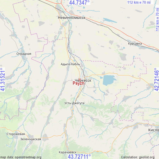
| Upper-left | 44.7347°, | 41.31521° |
| Center: | 44.23306°, | 42.01833° |
| Lower-right: | 43.72711°, | 42.72146° |
| Map W x H: | 112×112 km | = 69.6×69.6mi |
| max Lat: | 73.50819° ⇑90.5% North |
| Psyzh: | 44.23306° |
| min Lat: | ⇓9.5% South 41.28413° |
| min Long | Psyzh | max Long |
| -179.12198° | 42.01833° | 179.35046° |
| W 40.4%⇐ | ⇒59.6% E |
Elevation
Elevation of Psyzh is 552 m = 1811 ft, and this is 349.4 m = 1146 ft above average elevation for this country.
| Max E: |
2518 m = 8261 ft | 6.6% |
| Psyzh | 552 m 1811 ft | |
| Avg. | 202.6 m = 665 ft | |
Min E: |
-28 m = -92 ft | 93.4% |
See also: Russia elevation on elevation.city.
Geographical zone
Psyzh is located in North temperate zone (between Tropic of Cancer and the Arctic Circle). Distance of this Northern Tropic circle is 2312.3 km =1436.8 mi to South.| Distance of | km | miles | from Psyzh |
|---|---|---|---|
| North Pole | 5088.8 | 3162 | to North |
| Arctic Circle | 2482.9 | 1542.8 | to North |
| Tropic Cancer | 2312.3 | 1436.8 | to South |
| Equator | 4918.3 | 3056.1 | to South |


Nearby cities:
15 places around Psyzh: (largest is in red/bold)
• Adyge-Khabl’
12.9 km =8 mi,  330°
330°
• Ali-Berdukovskiy
34.9 km =21.7 mi,  219°
219°
• Bekeshevskaya
35.2 km =21.9 mi,  112°
112°
• Besleney
22.3 km =13.9 mi,  272°
272°
• Cherkessk
3.3 km =2.1 mi, 108°
• Druzhba
4.2 km =2.6 mi,  181°
181°
• Ikon-Khalk
11.5 km =7.1 mi,  314°
314°
• Ispravnaya
37.4 km =23.2 mi,  240°
240°
• Kavkazskiy
17.6 km =10.9 mi,  77°
77°
• Khabez
28.8 km =17.9 mi, 222°
• Kumysh
40.1 km =24.9 mi,  194°
194°
• Pravokubanskiy
36.7 km =22.8 mi,  196°
196°
• Sary-Tyuz
38.1 km =23.7 mi, 194°
• Udobnaya
37.4 km =23.2 mi,  263°
263°
• Ust’-Dzheguta
17 km =10.6 mi, 191°
Sources, notices
• [Note1] Compared only with cities in Russia existing in our database
• [Src1] Map data: © OpenStreetMap contributors (CC-BY-SA)
• [Src2] Other city data from geonames.org with taken over terms of usage.
• [Src3] Geographical zone / Annual Mean Temperature by Robert A. Rohde @ Wikipedia
