Cherkessk geodata
Cherkessk (Karachayevo-Cherkesiya Republic) is a seat of a first-order administrative division; located in Russia in Europe/Moscow (GMT+3) time zone. With population of 116,224 people, there are 172 cities with bigger population in this country. Compared to other cities in Russia, 90.6% of cities are located further ↑North; 59.4% of cities are located further →East and 92.9% of cities have lower elevation than Cherkessk. Note1


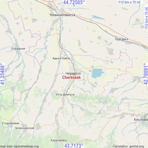
Cherkessk GPS coordinates[2]
44° 13' 23.988" North, 42° 3' 28.008" East
| Map corner | latitude | longitude |
|---|---|---|
| Upper-left | 44.72505°, | 41.35466° |
| Center: | 44.22333°, | 42.05778° |
| Lower-right: | 43.7173°, | 42.76091° |
| Map W x H: | 112.1×112.1 km | = 69.7×69.7mi |
| max Lat: | 73.50819° ⇑90.6% North |
| Cherkessk: | 44.22333° |
| min Lat: | ⇓9.4% South 41.28413° |
| min Long | Cherkessk | max Long |
| -179.12198° | 42.05778° | 179.35046° |
| W 40.6%⇐ | ⇒59.4% E |
Elevation
Elevation of Cherkessk is 532 m = 1745 ft, and this is 329.4 m = 1081 ft above average elevation for this country.
| Max E: |
2518 m = 8261 ft | 7.1% |
| Cherkessk | 532 m 1745 ft | |
| Avg. | 202.6 m = 665 ft | |
Min E: |
-28 m = -92 ft | 92.9% |
See also: Cherkessk elevation on elevation.city.
Geographical zone
Cherkessk is located in North temperate zone (between Tropic of Cancer and the Arctic Circle). Distance of this Northern Tropic circle is 2311.3 km =1436.2 mi to South.| Distance of | km | miles | from Cherkessk |
|---|---|---|---|
| North Pole | 5089.9 | 3162.7 | to North |
| Arctic Circle | 2484 | 1543.5 | to North |
| Tropic Cancer | 2311.3 | 1436.2 | to South |
| Equator | 4917.2 | 3055.4 | to South |


Nearby cities:
15 places around Cherkessk: (largest is in red/bold)
• Adyge-Khabl’
15.5 km =9.6 mi,  322°
322°
• Ali-Berdukovskiy
36.2 km =22.5 mi,  224°
224°
• Bekeshevskaya
31.9 km =19.8 mi,  112°
112°
• Besleney
25.5 km =15.8 mi,  274°
274°
• Druzhba
4.5 km =2.8 mi,  226°
226°
• Ikon-Khalk
14.6 km =9.1 mi,  308°
308°
• Ispravnaya
39.7 km =24.7 mi,  244°
244°
• Kavkazskiy
14.9 km =9.3 mi,  70°
70°
• Khabez
30.3 km =18.8 mi, 228°
• Kumysh
40 km =24.9 mi,  199°
199°
• Pravokubanskiy
36.8 km =22.9 mi, 202°
• Psyzh
3.3 km =2.1 mi,  288°
288°
• Sary-Tyuz
38 km =23.6 mi, 199°
• Udarnyy
38.3 km =23.8 mi, 68°
• Ust’-Dzheguta
16.9 km =10.5 mi, 202°
Sources, notices
• [Note1] Compared only with cities in Russia existing in our database
• [Src1] Map data: © OpenStreetMap contributors (CC-BY-SA)
• [Src2] Other city data from geonames.org with taken over terms of usage.
• [Src3] Geographical zone / Annual Mean Temperature by Robert A. Rohde @ Wikipedia
