Achikulak geodata
Achikulak (Stavropol’ Kray) is a populated place; located in Russia in Europe/Moscow (GMT+3) time zone. With population of 7,040 people, there are 1990 cities with bigger population in this country. Compared to other cities in Russia, 89.3% of cities are located further ↑North; 50.4% of cities are located further →East and 80.9% of cities have higher elevation than Achikulak. Note1


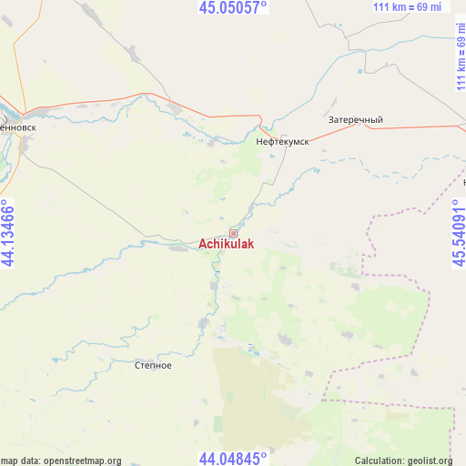
Achikulak GPS coordinates[2]
44° 33' 6.012" North, 44° 50' 16.008" East
| Map corner | latitude | longitude |
|---|---|---|
| Upper-left | 45.05057°, | 44.13466° |
| Center: | 44.55167°, | 44.83778° |
| Lower-right: | 44.04845°, | 45.54091° |
| Map W x H: | 111.4×111.4 km | = 69.2×69.2mi |
| max Lat: | 73.50819° ⇑89.3% North |
| Achikulak: | 44.55167° |
| min Lat: | ⇓10.7% South 41.28413° |
| min Long | Achikulak | max Long |
| -179.12198° | 44.83778° | 179.35046° |
| W 49.6%⇐ | ⇒50.4% E |
Elevation
Elevation of Achikulak is 68 m = 223 ft, and this is 134.6 m = 442 ft below average elevation for this country.
| Max E: |
2518 m = 8261 ft | 80.9% |
| Avg. | 202.6 m = 665 ft | |
| Achikulak | 68 m = 223 ft | |
Min E: |
-28 m = -92 ft | 19.1% |
See also: Russia elevation on elevation.city.
Geographical zone
Achikulak is located in North temperate zone (between Tropic of Cancer and the Arctic Circle). Distance of this Northern Tropic circle is 2347.8 km =1458.9 mi to South.| Distance of | km | miles | from Achikulak |
|---|---|---|---|
| North Pole | 5053.4 | 3140 | to North |
| Arctic Circle | 2447.5 | 1520.8 | to North |
| Tropic Cancer | 2347.8 | 1458.9 | to South |
| Equator | 4953.7 | 3078.1 | to South |


Nearby cities:
15 places around Achikulak: (largest is in red/bold)
• Irgakly
22.2 km =13.8 mi,  197°
197°
• Kara-Tyube
48.3 km =30 mi,  79°
79°
• Kayasula
28.3 km =17.6 mi,  152°
152°
• Levokumskoye
33.2 km =20.6 mi,  335°
335°
• Nadezhda
53.7 km =33.4 mi, 200°
• Neftekumsk
25.8 km =16 mi,  28°
28°
• Orlovka
54.7 km =34 mi,  286°
286°
• Pokoynoye
54.5 km =33.9 mi,  301°
301°
• Praskoveya
54.6 km =33.9 mi, 293°
• Pravokumskoye
28.5 km =17.7 mi,  328°
328°
• Solomenskoye
53.6 km =33.3 mi,  225°
225°
• Stepnoye
37.1 km =23.1 mi,  212°
212°
• Urozhaynoye
27.2 km =16.9 mi,  14°
14°
• Vostochny
57.3 km =35.6 mi,  242°
242°
• Zaterechnyy
39.8 km =24.7 mi,  47°
47°
Sources, notices
• [Note1] Compared only with cities in Russia existing in our database
• [Src1] Map data: © OpenStreetMap contributors (CC-BY-SA)
• [Src2] Other city data from geonames.org with taken over terms of usage.
• [Src3] Geographical zone / Annual Mean Temperature by Robert A. Rohde @ Wikipedia
