Mendeleyevskiy geodata
Mendeleyevskiy (Tula) is a section of populated place; located in Russia in Europe/Moscow (GMT+3) time zone. With population of 9,350 people, there are 1608 cities with bigger population in this country. Compared to other cities in Russia, 54% of cities are located further ↑North; 80.8% of cities are located further →East and 79.5% of cities have lower elevation than Mendeleyevskiy. Note1


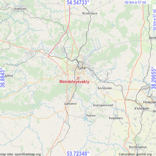
Mendeleyevskiy GPS coordinates[2]
54° 8' 14.82" North, 37° 35' 14.712" East
| Map corner | latitude | longitude |
|---|---|---|
| Upper-left | 54.54733°, | 36.8843° |
| Center: | 54.13745°, | 37.58742° |
| Lower-right: | 53.72348°, | 38.29055° |
| Map W x H: | 91.6×91.6 km | = 56.9×56.9mi |
| max Lat: | 73.50819° ⇑54% North |
| Mendeleyevskiy: | 54.13745° |
| min Lat: | ⇓46% South 41.28413° |
| min Long | Mendeleyevskiy | max Long |
| -179.12198° | 37.58742° | 179.35046° |
| W 19.2%⇐ | ⇒80.8% E |
Elevation
Elevation of Mendeleyevskiy is 244 m = 801 ft, and this is 41.4 m = 136 ft above average elevation for this country.
| Max E: |
2518 m = 8261 ft | 20.5% |
| Mendeleyevskiy | 244 m 801 ft | |
| Avg. | 202.6 m = 665 ft | |
Min E: |
-28 m = -92 ft | 79.5% |
See also: Russia elevation on elevation.city.
Geographical zone
Mendeleyevskiy is located in North temperate zone (between Tropic of Cancer and the Arctic Circle). Distance of this North polar circle is 1381.7 km =858.5 mi to North.| Distance of | km | miles | from Mendeleyevskiy |
|---|---|---|---|
| North Pole | 3987.5 | 2477.7 | to North |
| Arctic Circle | 1381.7 | 858.5 | to North |
| Tropic Cancer | 3413.6 | 2121.1 | to South |
| Equator | 6019.5 | 3740.3 | to South |


Nearby cities:
15 places around Mendeleyevskiy: (largest is in red/bold)
• Barsuki
15.6 km =9.7 mi,  335°
335°
• Bolokhovo
16.8 km =10.4 mi,  110°
110°
• Borodinskiy
21.6 km =13.4 mi,  135°
135°
• Gorelki
13.3 km =8.3 mi,  6°
6°
• Kosaya Gora
3.5 km =2.2 mi,  233°
233°
• Leninskiy
18.7 km =11.6 mi,  333°
333°
• Lomintsevskiy
17.6 km =10.9 mi,  163°
163°
• Pervomayskiy
11.5 km =7.1 mi,  206°
206°
• Revyakino
25.8 km =16 mi, 10°
• Rozhdestvenskiy
17.6 km =10.9 mi,  356°
356°
• Shchëkino
15.3 km =9.5 mi,  196°
196°
• Shvartsevskiy
26.8 km =16.7 mi,  100°
100°
• Skuratovskiy
4.1 km =2.5 mi,  165°
165°
• Tula
6.8 km =4.2 mi,  17°
17°
• Yasnaya Polyana
8.7 km =5.4 mi, 208°
Sources, notices
• [Note1] Compared only with cities in Russia existing in our database
• [Src1] Map data: © OpenStreetMap contributors (CC-BY-SA)
• [Src2] Other city data from geonames.org with taken over terms of usage.
• [Src3] Geographical zone / Annual Mean Temperature by Robert A. Rohde @ Wikipedia
