Rozhdestvenskiy geodata
Rozhdestvenskiy (Tula) is a populated place; located in Russia in Europe/Moscow (GMT+3) time zone. With population of 6,222 people, there are 2198 cities with bigger population in this country. Compared to other cities in Russia, 52.8% of cities are located further ↑North; 80.9% of cities are located further →East and 73.7% of cities have lower elevation than Rozhdestvenskiy. Note1


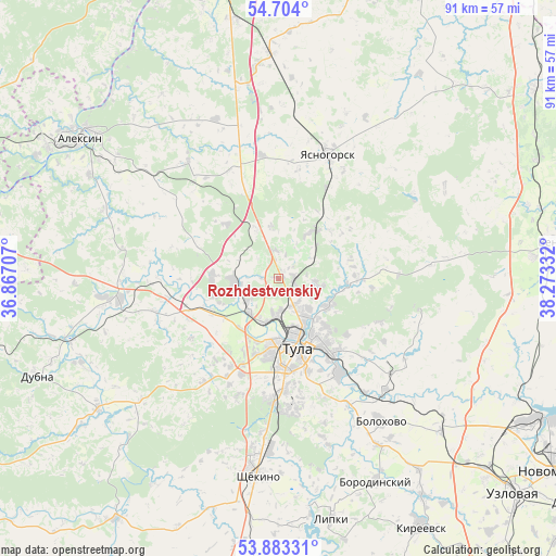
Rozhdestvenskiy GPS coordinates[2]
54° 17' 44.52" North, 37° 34' 12.684" East
| Map corner | latitude | longitude |
|---|---|---|
| Upper-left | 54.704°, | 36.86707° |
| Center: | 54.2957°, | 37.57019° |
| Lower-right: | 53.88331°, | 38.27332° |
| Map W x H: | 91.3×91.3 km | = 56.7×56.7mi |
| max Lat: | 73.50819° ⇑52.8% North |
| Rozhdestvenskiy: | 54.2957° |
| min Lat: | ⇓47.2% South 41.28413° |
| min Long | Rozhdestvenskiy | max Long |
| -179.12198° | 37.57019° | 179.35046° |
| W 19.1%⇐ | ⇒80.9% E |
Elevation
Elevation of Rozhdestvenskiy is 211 m = 692 ft, and this is 8.4 m = 28 ft above average elevation for this country.
| Max E: |
2518 m = 8261 ft | 26.3% |
| Rozhdestvenskiy | 211 m 692 ft | |
| Avg. | 202.6 m = 665 ft | |
Min E: |
-28 m = -92 ft | 73.7% |
See also: Russia elevation on elevation.city.
Geographical zone
Rozhdestvenskiy is located in North temperate zone (between Tropic of Cancer and the Arctic Circle). Distance of this North polar circle is 1364.1 km =847.6 mi to North.| Distance of | km | miles | from Rozhdestvenskiy |
|---|---|---|---|
| North Pole | 3969.9 | 2466.8 | to North |
| Arctic Circle | 1364.1 | 847.6 | to North |
| Tropic Cancer | 3431.2 | 2132 | to South |
| Equator | 6037.1 | 3751.3 | to South |


Nearby cities:
15 places around Rozhdestvenskiy: (largest is in red/bold)
• Barsuki
6.3 km =3.9 mi,  237°
237°
• Bolokhovo
29 km =18 mi,  144°
144°
• Gorelki
5.1 km =3.2 mi,  149°
149°
• Kosaya Gora
19.7 km =12.2 mi,  184°
184°
• Leninskiy
7.3 km =4.5 mi,  262°
262°
• Lomintsevskiy
35 km =21.7 mi,  169°
169°
• Mendeleyevskiy
17.6 km =10.9 mi, 176°
• Novogurovskiy
24.4 km =15.2 mi,  321°
321°
• Pervomayskiy
28.2 km =17.5 mi,  188°
188°
• Revyakino
9.8 km =6.1 mi,  37°
37°
• Shchëkino
32.5 km =20.2 mi, 185°
• Skuratovskiy
21.7 km =13.5 mi, 174°
• Tula
11.5 km =7.1 mi,  164°
164°
• Yasnaya Polyana
25.4 km =15.8 mi, 186°
• Yasnogorsk
22.2 km =13.8 mi,  21°
21°
Sources, notices
• [Note1] Compared only with cities in Russia existing in our database
• [Src1] Map data: © OpenStreetMap contributors (CC-BY-SA)
• [Src2] Other city data from geonames.org with taken over terms of usage.
• [Src3] Geographical zone / Annual Mean Temperature by Robert A. Rohde @ Wikipedia
