Pervomaysk geodata
Pervomaysk (Nizhny Novgorod Oblast) is a populated place; located in Russia in Europe/Moscow (GMT+3) time zone. With population of 14,810 people, there are 1101 cities with bigger population in this country. Compared to other cities in Russia, 51.8% of cities are located further ↓South; 53.5% of cities are located further →East and 56.8% of cities have lower elevation than Pervomaysk. Note1


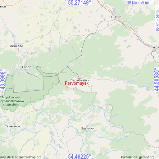
Pervomaysk GPS coordinates[2]
54° 52' 8.04" North, 43° 48' 9.792" East
| Map corner | latitude | longitude |
|---|---|---|
| Upper-left | 55.27149°, | 43.0996° |
| Center: | 54.8689°, | 43.80272° |
| Lower-right: | 54.46225°, | 44.50585° |
| Map W x H: | 90×90 km | = 55.9×55.9mi |
| max Lat: | 73.50819° ⇑48.2% North |
| Pervomaysk: | 54.8689° |
| min Lat: | ⇓51.8% South 41.28413° |
| min Long | Pervomaysk | max Long |
| -179.12198° | 43.80272° | 179.35046° |
| W 46.5%⇐ | ⇒53.5% E |
Elevation
Elevation of Pervomaysk is 160 m = 525 ft, and this is 42.6 m = 140 ft below average elevation for this country.
| Max E: |
2518 m = 8261 ft | 43.2% |
| Avg. | 202.6 m = 665 ft | |
| Pervomaysk | 160 m = 525 ft | |
Min E: |
-28 m = -92 ft | 56.8% |
See also: Russia elevation on elevation.city.
Geographical zone
Pervomaysk is located in North temperate zone (between Tropic of Cancer and the Arctic Circle). Distance of this North polar circle is 1300.3 km =808 mi to North.| Distance of | km | miles | from Pervomaysk |
|---|---|---|---|
| North Pole | 3906.2 | 2427.2 | to North |
| Arctic Circle | 1300.3 | 808 | to North |
| Tropic Cancer | 3494.9 | 2171.6 | to South |
| Equator | 6100.8 | 3790.9 | to South |


Nearby cities:
15 places around Pervomaysk: (largest is in red/bold)
• Ardatov
61.2 km =38 mi,  312°
312°
• Arzamas
58.5 km =36.4 mi,  2°
2°
• Diveyevo
40.7 km =25.3 mi,  298°
298°
• Imeni Stepana Razina
31.7 km =19.7 mi,  85°
85°
• Krasnoslobodsk
49.3 km =30.6 mi,  180°
180°
• Lesogorsk
26.8 km =16.7 mi,  18°
18°
• Lukoyanov
46.6 km =29 mi,  67°
67°
• Sarov
31.5 km =19.6 mi,  283°
283°
• Satis
17.1 km =10.6 mi, 2°
• Satis
37.1 km =23.1 mi, 279°
• Shatki
41.1 km =25.5 mi,  29°
29°
• Sosnovka
36.8 km =22.9 mi,  241°
241°
• Temnikov
46.1 km =28.6 mi,  234°
234°
• Voznesenskoye
66.9 km =41.6 mi,  272°
272°
• Vyyezdnoye
57 km =35.4 mi,  358°
358°
Sources, notices
• [Note1] Compared only with cities in Russia existing in our database
• [Src1] Map data: © OpenStreetMap contributors (CC-BY-SA)
• [Src2] Other city data from geonames.org with taken over terms of usage.
• [Src3] Geographical zone / Annual Mean Temperature by Robert A. Rohde @ Wikipedia
