Vyyezdnoye geodata
Vyyezdnoye (Nizhny Novgorod Oblast) is a populated place; located in Russia in Europe/Moscow (GMT+3) time zone. With population of 7,857 people, there are 1839 cities with bigger population in this country. Compared to other cities in Russia, 56.9% of cities are located further ↓South; 53.6% of cities are located further →East and 62.5% of cities have higher elevation than Vyyezdnoye. Note1


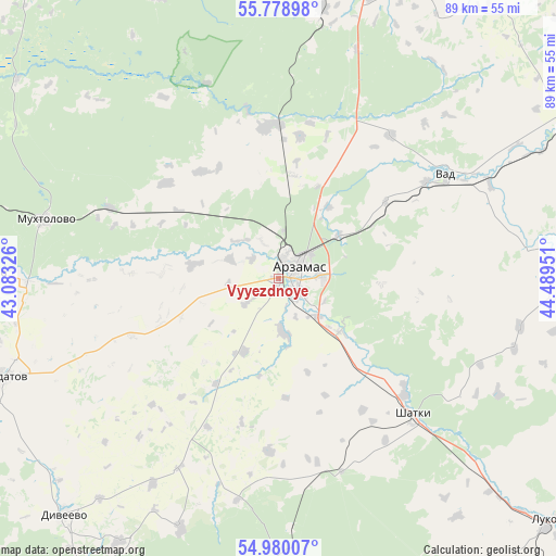
Vyyezdnoye GPS coordinates[2]
55° 22' 53.544" North, 43° 47' 10.968" East
| Map corner | latitude | longitude |
|---|---|---|
| Upper-left | 55.77898°, | 43.08326° |
| Center: | 55.38154°, | 43.78638° |
| Lower-right: | 54.98007°, | 44.48951° |
| Map W x H: | 88.8×88.8 km | = 55.2×55.2mi |
| max Lat: | 73.50819° ⇑43.1% North |
| Vyyezdnoye: | 55.38154° |
| min Lat: | ⇓56.9% South 41.28413° |
| min Long | Vyyezdnoye | max Long |
| -179.12198° | 43.78638° | 179.35046° |
| W 46.4%⇐ | ⇒53.6% E |
Elevation
Elevation of Vyyezdnoye is 119 m = 390 ft, and this is 83.6 m = 274 ft below average elevation for this country.
| Max E: |
2518 m = 8261 ft | 62.5% |
| Avg. | 202.6 m = 665 ft | |
| Vyyezdnoye | 119 m = 390 ft | |
Min E: |
-28 m = -92 ft | 37.5% |
See also: Russia elevation on elevation.city.
Geographical zone
Vyyezdnoye is located in North temperate zone (between Tropic of Cancer and the Arctic Circle). Distance of this North polar circle is 1243.3 km =772.6 mi to North.| Distance of | km | miles | from Vyyezdnoye |
|---|---|---|---|
| North Pole | 3849.2 | 2391.8 | to North |
| Arctic Circle | 1243.3 | 772.6 | to North |
| Tropic Cancer | 3551.9 | 2207 | to South |
| Equator | 6157.9 | 3826.3 | to South |


Nearby cities:
15 places around Vyyezdnoye: (largest is in red/bold)
• Ardatov
46.3 km =28.8 mi,  250°
250°
• Arzamas
3.7 km =2.3 mi,  66°
66°
• Chernukha
24.1 km =15 mi,  355°
355°
• Dal’neye Konstantinovo
51.5 km =32 mi,  22°
22°
• Diveyevo
51.1 km =31.8 mi,  222°
222°
• Gremyachevo
48 km =29.8 mi,  271°
271°
• Lesogorsk
32.9 km =20.4 mi,  163°
163°
• Malaya Pitsa
49.2 km =30.6 mi,  30°
30°
• Mukhtolovo
38.2 km =23.7 mi,  284°
284°
• Perevoz
53.4 km =33.2 mi,  63°
63°
• Pervomaysk
57 km =35.4 mi,  178°
178°
• Satis
39.9 km =24.8 mi, 177°
• Shatki
30.3 km =18.8 mi,  135°
135°
• Surovatikha
43.2 km =26.8 mi,  9°
9°
• Vad
31.5 km =19.6 mi, 58°
Sources, notices
• [Note1] Compared only with cities in Russia existing in our database
• [Src1] Map data: © OpenStreetMap contributors (CC-BY-SA)
• [Src2] Other city data from geonames.org with taken over terms of usage.
• [Src3] Geographical zone / Annual Mean Temperature by Robert A. Rohde @ Wikipedia
