Sarov geodata
Sarov (Nizhny Novgorod Oblast) is a populated place; located in Russia in Europe/Moscow (GMT+3) time zone. With population of 88,000 people, there are 241 cities with bigger population in this country. Compared to other cities in Russia, 52.5% of cities are located further ↓South; 55.3% of cities are located further →East and 50.7% of cities have higher elevation than Sarov. Note1


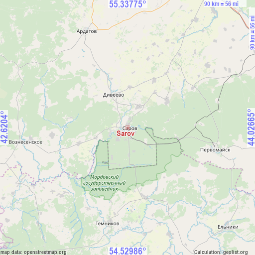
Sarov GPS coordinates[2]
54° 56' 8.988" North, 43° 19' 24.672" East
| Map corner | latitude | longitude |
|---|---|---|
| Upper-left | 55.33775°, | 42.6204° |
| Center: | 54.93583°, | 43.32352° |
| Lower-right: | 54.52986°, | 44.02665° |
| Map W x H: | 89.8×89.8 km | = 55.8×55.8mi |
| max Lat: | 73.50819° ⇑47.5% North |
| Sarov: | 54.93583° |
| min Lat: | ⇓52.5% South 41.28413° |
| min Long | Sarov | max Long |
| -179.12198° | 43.32352° | 179.35046° |
| W 44.7%⇐ | ⇒55.3% E |
Elevation
Elevation of Sarov is 143 m = 469 ft, and this is 59.6 m = 196 ft below average elevation for this country.
| Max E: |
2518 m = 8261 ft | 50.7% |
| Avg. | 202.6 m = 665 ft | |
| Sarov | 143 m = 469 ft | |
Min E: |
-28 m = -92 ft | 49.3% |
See also: Sarov elevation on elevation.city.
Geographical zone
Sarov is located in North temperate zone (between Tropic of Cancer and the Arctic Circle). Distance of this North polar circle is 1292.9 km =803.4 mi to North.| Distance of | km | miles | from Sarov |
|---|---|---|---|
| North Pole | 3898.8 | 2422.6 | to North |
| Arctic Circle | 1292.9 | 803.4 | to North |
| Tropic Cancer | 3502.4 | 2176.3 | to South |
| Equator | 6108.3 | 3795.5 | to South |


Nearby cities:
15 places around Sarov: (largest is in red/bold)
• Ardatov
37 km =23 mi,  337°
337°
• Barashevo
53.1 km =33 mi,  212°
212°
• Diveyevo
13 km =8.1 mi, 336°
• Gremyachevo
54.1 km =33.6 mi, 339°
• Lesogorsk
43 km =26.7 mi,  65°
65°
• Mukhtolovo
59.6 km =37 mi,  352°
352°
• Pervomaysk
31.5 km =19.6 mi,  103°
103°
• Satis
6.2 km =3.9 mi,  256°
256°
• Satis
32.8 km =20.4 mi, 72°
• Shatki
58.3 km =36.2 mi,  61°
61°
• Sosnovka
25 km =15.5 mi,  183°
183°
• Temnikov
34.7 km =21.6 mi,  191°
191°
• Ten’gushevo
42.9 km =26.7 mi,  244°
244°
• Voznesenskoye
36.6 km =22.7 mi, 261°
• Vyyezdnoye
57.6 km =35.8 mi,  30°
30°
Sources, notices
• [Note1] Compared only with cities in Russia existing in our database
• [Src1] Map data: © OpenStreetMap contributors (CC-BY-SA)
• [Src2] Other city data from geonames.org with taken over terms of usage.
• [Src3] Geographical zone / Annual Mean Temperature by Robert A. Rohde @ Wikipedia
