Perevoz geodata
Perevoz (Nizhny Novgorod Oblast) is a populated place; located in Russia in Europe/Moscow (GMT+3) time zone. With population of 9,228 people, there are 1622 cities with bigger population in this country. Compared to other cities in Russia, 59.5% of cities are located further ↓South; 51.4% of cities are located further →East and 71.5% of cities have higher elevation than Perevoz. Note1


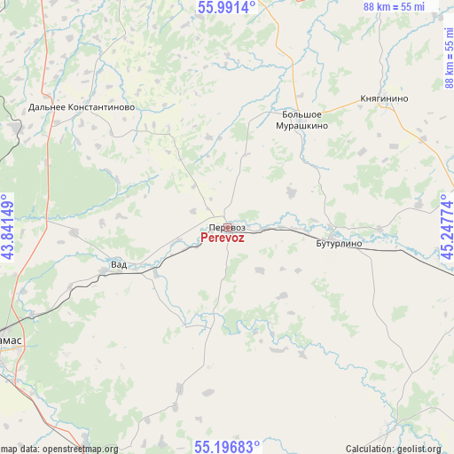
Perevoz GPS coordinates[2]
55° 35' 46.068" North, 44° 32' 40.596" East
| Map corner | latitude | longitude |
|---|---|---|
| Upper-left | 55.9914°, | 43.84149° |
| Center: | 55.59613°, | 44.54461° |
| Lower-right: | 55.19683°, | 45.24774° |
| Map W x H: | 88.3×88.3 km | = 54.9×54.9mi |
| max Lat: | 73.50819° ⇑40.5% North |
| Perevoz: | 55.59613° |
| min Lat: | ⇓59.5% South 41.28413° |
| min Long | Perevoz | max Long |
| -179.12198° | 44.54461° | 179.35046° |
| W 48.6%⇐ | ⇒51.4% E |
Elevation
Elevation of Perevoz is 99 m = 325 ft, and this is 103.6 m = 340 ft below average elevation for this country.
| Max E: |
2518 m = 8261 ft | 71.5% |
| Avg. | 202.6 m = 665 ft | |
| Perevoz | 99 m = 325 ft | |
Min E: |
-28 m = -92 ft | 28.5% |
See also: Russia elevation on elevation.city.
Geographical zone
Perevoz is located in North temperate zone (between Tropic of Cancer and the Arctic Circle). Distance of this North polar circle is 1219.5 km =757.8 mi to North.| Distance of | km | miles | from Perevoz |
|---|---|---|---|
| North Pole | 3825.4 | 2377 | to North |
| Arctic Circle | 1219.5 | 757.8 | to North |
| Tropic Cancer | 3575.8 | 2221.9 | to South |
| Equator | 6181.7 | 3841.1 | to South |


Nearby cities:
15 places around Perevoz: (largest is in red/bold)
• Arzamas
49.7 km =30.9 mi,  243°
243°
• Bol’shoye Murashkino
25.3 km =15.7 mi,  34°
34°
• Buturlino
22.4 km =13.9 mi,  98°
98°
• Chernukha
49.6 km =30.8 mi,  270°
270°
• Dal’neye Konstantinovo
36.8 km =22.9 mi,  310°
310°
• Gagino
51 km =31.7 mi,  142°
142°
• Knyaginino
39.7 km =24.7 mi,  50°
50°
• Lyskovo
57.7 km =35.9 mi, 32°
• Malaya Pitsa
28.9 km =18 mi, 309°
• Pamyat’ Parizhskoy Kommuny
56.6 km =35.2 mi,  356°
356°
• Rabotki
49.6 km =30.8 mi,  4°
4°
• Shatki
52.5 km =32.6 mi,  210°
210°
• Surovatikha
44.7 km =27.8 mi,  294°
294°
• Vad
22.2 km =13.8 mi,  250°
250°
• Vyyezdnoye
53.4 km =33.2 mi, 243°
Sources, notices
• [Note1] Compared only with cities in Russia existing in our database
• [Src1] Map data: © OpenStreetMap contributors (CC-BY-SA)
• [Src2] Other city data from geonames.org with taken over terms of usage.
• [Src3] Geographical zone / Annual Mean Temperature by Robert A. Rohde @ Wikipedia
