Lyskovo geodata
Lyskovo (Nizhny Novgorod Oblast) is a populated place; located in Russia in Europe/Moscow (GMT+3) time zone. With population of 23,570 people, there are 782 cities with bigger population in this country. Compared to other cities in Russia, 67% of cities are located further ↓South; 50.2% of cities are located further ←West and 72.6% of cities have higher elevation than Lyskovo. Note1


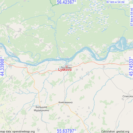
Lyskovo GPS coordinates[2]
56° 1' 58.152" North, 45° 2' 31.92" East
| Map corner | latitude | longitude |
|---|---|---|
| Upper-left | 56.42367°, | 44.33908° |
| Center: | 56.03282°, | 45.0422° |
| Lower-right: | 55.63797°, | 45.74533° |
| Map W x H: | 87.4×87.4 km | = 54.3×54.3mi |
| max Lat: | 73.50819° ⇑33% North |
| Lyskovo: | 56.03282° |
| min Lat: | ⇓67% South 41.28413° |
| min Long | Lyskovo | max Long |
| -179.12198° | 45.0422° | 179.35046° |
| W 50.2%⇐ | ⇒49.8% E |
Elevation
Elevation of Lyskovo is 95 m = 312 ft, and this is 107.6 m = 353 ft below average elevation for this country.
| Max E: |
2518 m = 8261 ft | 72.6% |
| Avg. | 202.6 m = 665 ft | |
| Lyskovo | 95 m = 312 ft | |
Min E: |
-28 m = -92 ft | 27.4% |
See also: Russia elevation on elevation.city.
Geographical zone
Lyskovo is located in North temperate zone (between Tropic of Cancer and the Arctic Circle). Distance of this North polar circle is 1170.9 km =727.6 mi to North.| Distance of | km | miles | from Lyskovo |
|---|---|---|---|
| North Pole | 3776.8 | 2346.8 | to North |
| Arctic Circle | 1170.9 | 727.6 | to North |
| Tropic Cancer | 3624.3 | 2252 | to South |
| Equator | 6230.3 | 3871.3 | to South |


Nearby cities:
15 places around Lyskovo: (largest is in red/bold)
• Bol’sheorlovskiy
51.2 km =31.8 mi,  327°
327°
• Bol’shoye Murashkino
32.4 km =20.1 mi,  210°
210°
• Buturlino
52.6 km =32.7 mi,  189°
189°
• Imeni M. I. Kalinina
47 km =29.2 mi,  290°
290°
• Kerzhenets
61.6 km =38.3 mi,  321°
321°
• Knyaginino
23.4 km =14.5 mi,  181°
181°
• Kstovo
53.9 km =33.5 mi,  283°
283°
• Malaya Pitsa
61.2 km =38 mi,  240°
240°
• Pamyat’ Parizhskoy Kommuny
34.9 km =21.7 mi, 283°
• Perevoz
57.7 km =35.9 mi, 212°
• Pervoye Maya
24.8 km =15.4 mi,  306°
306°
• Rabotki
27.3 km =17 mi,  272°
272°
• Spasskoye
45 km =28 mi,  115°
115°
• Vasil’sursk
61.4 km =38.2 mi,  79°
79°
• Vorotynets
51.1 km =31.8 mi,  86°
86°
Sources, notices
• [Note1] Compared only with cities in Russia existing in our database
• [Src1] Map data: © OpenStreetMap contributors (CC-BY-SA)
• [Src2] Other city data from geonames.org with taken over terms of usage.
• [Src3] Geographical zone / Annual Mean Temperature by Robert A. Rohde @ Wikipedia
