Manturovo geodata
Manturovo (Kursk) is a populated place; located in Russia in Europe/Moscow (GMT+3) time zone. With population of 2,755 people, there are 3872 cities with bigger population in this country. Compared to other cities in Russia, 72.8% of cities are located further ↑North; 84.4% of cities are located further →East and 72.3% of cities have lower elevation than Manturovo. Note1


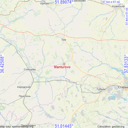
Manturovo GPS coordinates[2]
51° 27' 16.92" North, 37° 7' 41.52" East
| Map corner | latitude | longitude |
|---|---|---|
| Upper-left | 51.89074°, | 36.42508° |
| Center: | 51.4547°, | 37.1282° |
| Lower-right: | 51.01445°, | 37.83133° |
| Map W x H: | 97.4×97.4 km | = 60.5×60.5mi |
| max Lat: | 73.50819° ⇑72.8% North |
| Manturovo: | 51.4547° |
| min Lat: | ⇓27.2% South 41.28413° |
| min Long | Manturovo | max Long |
| -179.12198° | 37.1282° | 179.35046° |
| W 15.6%⇐ | ⇒84.4% E |
Elevation
Elevation of Manturovo is 206 m = 676 ft, and this is 3.4 m = 11 ft above average elevation for this country.
| Max E: |
2518 m = 8261 ft | 27.7% |
| Manturovo | 206 m 676 ft | |
| Avg. | 202.6 m = 665 ft | |
Min E: |
-28 m = -92 ft | 72.3% |
See also: Russia elevation on elevation.city.
Geographical zone
Manturovo is located in North temperate zone (between Tropic of Cancer and the Arctic Circle). Distance of this North polar circle is 1679.9 km =1043.8 mi to North.| Distance of | km | miles | from Manturovo |
|---|---|---|---|
| North Pole | 4285.8 | 2663.1 | to North |
| Arctic Circle | 1679.9 | 1043.8 | to North |
| Tropic Cancer | 3115.3 | 1935.8 | to South |
| Equator | 5721.2 | 3555 | to South |


Nearby cities:
15 places around Manturovo: (largest is in red/bold)
• Cheremisinovo
48.8 km =30.3 mi,  11°
11°
• Gorshechnoye
63.4 km =39.4 mi,  82°
82°
• Gubkin
34.8 km =21.6 mi,  123°
123°
• Kirovskiy
32.3 km =20.1 mi,  262°
262°
• Kshenskiy
58.9 km =36.6 mi,  43°
43°
• Oboyan’
65 km =40.4 mi,  245°
245°
• Pristen’
38.7 km =24 mi,  230°
230°
• Prokhorovka
54 km =33.6 mi,  210°
210°
• Shchigry
49.3 km =30.6 mi,  341°
341°
• Skorodnoye
43.2 km =26.8 mi,  170°
170°
• Solntsevo
26.5 km =16.5 mi, 261°
• Staryy Oskol
52.5 km =32.6 mi,  109°
109°
• Tim
18.6 km =11.6 mi,  359°
359°
• Troitskiy
29.5 km =18.3 mi, 111°
• Vyshneye Dolgoye
70.3 km =43.7 mi,  15°
15°
Sources, notices
• [Note1] Compared only with cities in Russia existing in our database
• [Src1] Map data: © OpenStreetMap contributors (CC-BY-SA)
• [Src2] Other city data from geonames.org with taken over terms of usage.
• [Src3] Geographical zone / Annual Mean Temperature by Robert A. Rohde @ Wikipedia
