Troitskiy geodata
Troitskiy (Belgorod Oblast) is a populated place; located in Russia in Europe/Moscow (GMT+3) time zone. With population of 6,236 people, there are 2194 cities with bigger population in this country. Compared to other cities in Russia, 73.3% of cities are located further ↑North; 81.5% of cities are located further →East and 79.2% of cities have lower elevation than Troitskiy. Note1


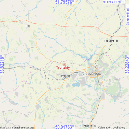
Troitskiy GPS coordinates[2]
51° 21' 31.68" North, 37° 31' 31.08" East
| Map corner | latitude | longitude |
|---|---|---|
| Upper-left | 51.79576°, | 36.82218° |
| Center: | 51.3588°, | 37.5253° |
| Lower-right: | 50.91763°, | 38.22843° |
| Map W x H: | 97.6×97.6 km | = 60.6×60.6mi |
| max Lat: | 73.50819° ⇑73.3% North |
| Troitskiy: | 51.3588° |
| min Lat: | ⇓26.7% South 41.28413° |
| min Long | Troitskiy | max Long |
| -179.12198° | 37.5253° | 179.35046° |
| W 18.5%⇐ | ⇒81.5% E |
Elevation
Elevation of Troitskiy is 241 m = 791 ft, and this is 38.4 m = 126 ft above average elevation for this country.
| Max E: |
2518 m = 8261 ft | 20.8% |
| Troitskiy | 241 m 791 ft | |
| Avg. | 202.6 m = 665 ft | |
Min E: |
-28 m = -92 ft | 79.2% |
See also: Russia elevation on elevation.city.
Geographical zone
Troitskiy is located in North temperate zone (between Tropic of Cancer and the Arctic Circle). Distance of this North polar circle is 1690.6 km =1050.5 mi to North.| Distance of | km | miles | from Troitskiy |
|---|---|---|---|
| North Pole | 4296.5 | 2669.7 | to North |
| Arctic Circle | 1690.6 | 1050.5 | to North |
| Tropic Cancer | 3104.6 | 1929.1 | to South |
| Equator | 5710.6 | 3548.4 | to South |


Nearby cities:
15 places around Troitskiy: (largest is in red/bold)
• Cheremisinovo
61.3 km =38.1 mi,  342°
342°
• Chernyanka
50.4 km =31.3 mi,  157°
157°
• Gorshechnoye
39.9 km =24.8 mi,  62°
62°
• Gubkin
8.7 km =5.4 mi,  170°
170°
• Kirovskiy
59.9 km =37.2 mi,  276°
276°
• Kshenskiy
55.2 km =34.3 mi,  13°
13°
• Manturovo
29.5 km =18.3 mi,  291°
291°
• Nizhnedevitsk
61.7 km =38.3 mi,  70°
70°
• Olym
57.4 km =35.7 mi,  51°
51°
• Pristen’
59.3 km =36.8 mi,  256°
256°
• Rogovatoye
61.2 km =38 mi,  103°
103°
• Skorodnoye
38.1 km =23.7 mi,  212°
212°
• Solntsevo
54.2 km =33.7 mi, 277°
• Staryy Oskol
23 km =14.3 mi,  107°
107°
• Tim
40.3 km =25 mi,  316°
316°
Sources, notices
• [Note1] Compared only with cities in Russia existing in our database
• [Src1] Map data: © OpenStreetMap contributors (CC-BY-SA)
• [Src2] Other city data from geonames.org with taken over terms of usage.
• [Src3] Geographical zone / Annual Mean Temperature by Robert A. Rohde @ Wikipedia
