Prokhorovka geodata
Prokhorovka (Belgorod Oblast) is a populated place; located in Russia in Europe/Moscow (GMT+3) time zone. With population of 10,136 people, there are 1489 cities with bigger population in this country. Compared to other cities in Russia, 74.8% of cities are located further ↑North; 85.6% of cities are located further →East and 80.9% of cities have lower elevation than Prokhorovka. Note1


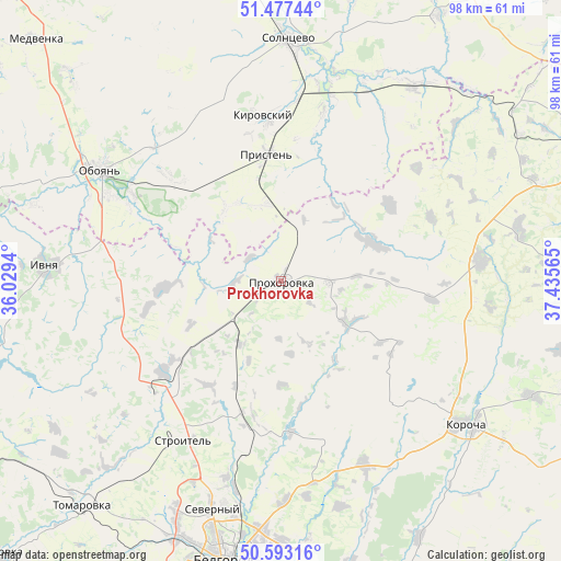
Prokhorovka GPS coordinates[2]
51° 2' 14.676" North, 36° 43' 57.072" East
| Map corner | latitude | longitude |
|---|---|---|
| Upper-left | 51.47744°, | 36.0294° |
| Center: | 51.03741°, | 36.73252° |
| Lower-right: | 50.59316°, | 37.43565° |
| Map W x H: | 98.3×98.3 km | = 61.1×61.1mi |
| max Lat: | 73.50819° ⇑74.8% North |
| Prokhorovka: | 51.03741° |
| min Lat: | ⇓25.2% South 41.28413° |
| min Long | Prokhorovka | max Long |
| -179.12198° | 36.73252° | 179.35046° |
| W 14.4%⇐ | ⇒85.6% E |
Elevation
Elevation of Prokhorovka is 256 m = 840 ft, and this is 53.4 m = 175 ft above average elevation for this country.
| Max E: |
2518 m = 8261 ft | 19.1% |
| Prokhorovka | 256 m 840 ft | |
| Avg. | 202.6 m = 665 ft | |
Min E: |
-28 m = -92 ft | 80.9% |
See also: Russia elevation on elevation.city.
Geographical zone
Prokhorovka is located in North temperate zone (between Tropic of Cancer and the Arctic Circle). Distance of this North polar circle is 1726.3 km =1072.7 mi to North.| Distance of | km | miles | from Prokhorovka |
|---|---|---|---|
| North Pole | 4332.2 | 2691.9 | to North |
| Arctic Circle | 1726.3 | 1072.7 | to North |
| Tropic Cancer | 3068.9 | 1906.9 | to South |
| Equator | 5674.8 | 3526.2 | to South |


Nearby cities:
15 places around Prokhorovka: (largest is in red/bold)
• Bekhteyevka
42.5 km =26.4 mi,  126°
126°
• Belgorod
48.6 km =30.2 mi,  192°
192°
• Ivnya
41.9 km =26 mi,  273°
273°
• Kirovskiy
42.4 km =26.3 mi,  353°
353°
• Korocha
40.4 km =25.1 mi, 128°
• Manturovo
54 km =33.6 mi,  30°
30°
• Oboyan’
37 km =23 mi,  301°
301°
• Pristen’
22.2 km =13.8 mi, 353°
• Razumnoye
56 km =34.8 mi,  183°
183°
• Severnyy
42 km =26.1 mi,  197°
197°
• Skorodnoye
34.8 km =21.6 mi,  83°
83°
• Solntsevo
42.4 km =26.3 mi,  1°
1°
• Stroitel’
33 km =20.5 mi,  211°
211°
• Tomarovka
52.7 km =32.7 mi,  221°
221°
• Yakovlevo
28 km =17.4 mi,  225°
225°
Sources, notices
• [Note1] Compared only with cities in Russia existing in our database
• [Src1] Map data: © OpenStreetMap contributors (CC-BY-SA)
• [Src2] Other city data from geonames.org with taken over terms of usage.
• [Src3] Geographical zone / Annual Mean Temperature by Robert A. Rohde @ Wikipedia
