Makhachkala geodata
Makhachkala (Dagestan) is a seat of a first-order administrative division; located in Russia in Europe/Moscow (GMT+3) time zone. With population of 497,959 people, there are 35 cities with bigger population in this country. Compared to other cities in Russia, 97.7% of cities are located further ↑North; 57.4% of cities are located further ←West and 98.1% of cities have higher elevation than Makhachkala. Note1


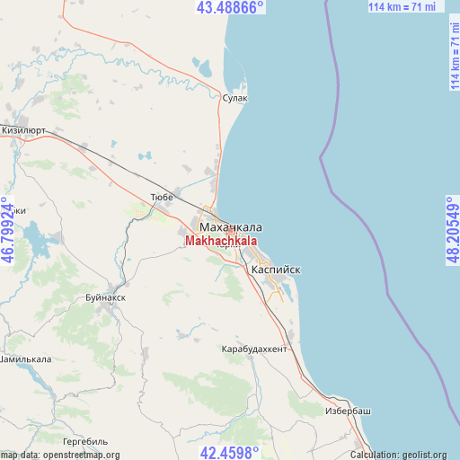
Makhachkala GPS coordinates[2]
42° 58' 34.968" North, 47° 30' 8.496" East
| Map corner | latitude | longitude |
|---|---|---|
| Upper-left | 43.48866°, | 46.79924° |
| Center: | 42.97638°, | 47.50236° |
| Lower-right: | 42.4598°, | 48.20549° |
| Map W x H: | 114.4×114.4 km | = 71.1×71.1mi |
| max Lat: | 73.50819° ⇑97.7% North |
| Makhachkala: | 42.97638° |
| min Lat: | ⇓2.3% South 41.28413° |
| min Long | Makhachkala | max Long |
| -179.12198° | 47.50236° | 179.35046° |
| W 57.4%⇐ | ⇒42.6% E |
Elevation
Elevation of Makhachkala is 4 m = 13 ft, and this is 198.6 m = 652 ft below average elevation for this country.
| Max E: |
2518 m = 8261 ft | 98.1% |
| Avg. | 202.6 m = 665 ft | |
| Makhachkala | 4 m = 13 ft | |
Min E: |
-28 m = -92 ft | 1.9% |
See also: Makhachkala elevation on elevation.city.
Geographical zone
Makhachkala is located in North temperate zone (between Tropic of Cancer and the Arctic Circle). Distance of this Northern Tropic circle is 2172.6 km =1350 mi to South.| Distance of | km | miles | from Makhachkala |
|---|---|---|---|
| North Pole | 5228.5 | 3248.8 | to North |
| Arctic Circle | 2622.6 | 1629.6 | to North |
| Tropic Cancer | 2172.6 | 1350 | to South |
| Equator | 4778.5 | 2969.2 | to South |


Nearby cities:
15 places around Makhachkala: (largest is in red/bold)
• Kafyr-Kumukh
32.3 km =20.1 mi,  241°
241°
• Karabudakhkent
30.2 km =18.8 mi,  169°
169°
• Kaspiysk
15.3 km =9.5 mi,  133°
133°
• Korkmaskala
17.7 km =11 mi,  287°
287°
• Kyakhulay
1.8 km =1.1 mi, 240°
• Leninkent
12.3 km =7.6 mi,  266°
266°
• Manas
31.2 km =19.4 mi,  152°
152°
• Manaskent
30.4 km =18.9 mi, 149°
• Novyy Khushet
9.8 km =6.1 mi, 151°
• Paraul
28.7 km =17.8 mi,  204°
204°
• Shamkhal
16.3 km =10.1 mi,  304°
304°
• Shamkhal-Termen
16.9 km =10.5 mi, 292°
• Sulak
33 km =20.5 mi,  1°
1°
• Tarki
3.6 km =2.2 mi,  189°
189°
• Tyube
17.8 km =11.1 mi, 297°
In other languages:
- In France: Makhatchkala
- In German: Machatschkala
- In Italian: Machačkala
- In Russian: Махачкала
Sources, notices
• [Note1] Compared only with cities in Russia existing in our database
• [Src1] Map data: © OpenStreetMap contributors (CC-BY-SA)
• [Src2] Other city data from geonames.org with taken over terms of usage.
• [Src3] Geographical zone / Annual Mean Temperature by Robert A. Rohde @ Wikipedia
