Manas geodata
Manas (Dagestan) is a populated place; located in Russia in Europe/Moscow (GMT+3) time zone. With population of 5,216 people, there are 2550 cities with bigger population in this country. Compared to other cities in Russia, 98.5% of cities are located further ↑North; 58% of cities are located further ←West and 83.4% of cities have higher elevation than Manas. Note1


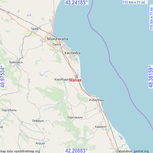
Manas GPS coordinates[2]
42° 43' 38.964" North, 47° 40' 42.456" East
| Map corner | latitude | longitude |
|---|---|---|
| Upper-left | 43.24185°, | 46.97534° |
| Center: | 42.72749°, | 47.67846° |
| Lower-right: | 42.20883°, | 48.38159° |
| Map W x H: | 114.9×114.9 km | = 71.4×71.4mi |
| max Lat: | 73.50819° ⇑98.5% North |
| Manas: | 42.72749° |
| min Lat: | ⇓1.5% South 41.28413° |
| min Long | Manas | max Long |
| -179.12198° | 47.67846° | 179.35046° |
| W 58%⇐ | ⇒42% E |
Elevation
Elevation of Manas is 56 m = 184 ft, and this is 146.6 m = 481 ft below average elevation for this country.
| Max E: |
2518 m = 8261 ft | 83.4% |
| Avg. | 202.6 m = 665 ft | |
| Manas | 56 m = 184 ft | |
Min E: |
-28 m = -92 ft | 16.6% |
See also: Russia elevation on elevation.city.
Geographical zone
Manas is located in North temperate zone (between Tropic of Cancer and the Arctic Circle). Distance of this Northern Tropic circle is 2144.9 km =1332.8 mi to South.| Distance of | km | miles | from Manas |
|---|---|---|---|
| North Pole | 5256.2 | 3266.1 | to North |
| Arctic Circle | 2650.3 | 1646.8 | to North |
| Tropic Cancer | 2144.9 | 1332.8 | to South |
| Equator | 4750.9 | 2952.1 | to South |


Nearby cities:
15 places around Manas: (largest is in red/bold)
• Achisu
8.4 km =5.2 mi,  177°
177°
• Dorgeli
32.1 km =19.9 mi,  257°
257°
• Gubden
20 km =12.4 mi,  207°
207°
• Gurbuki
14.4 km =8.9 mi, 206°
• Izberbash
23.2 km =14.4 mi,  139°
139°
• Karabudakhkent
9.3 km =5.8 mi, 257°
• Kaspiysk
17.4 km =10.8 mi,  349°
349°
• Kyakhulay
31.2 km =19.4 mi,  329°
329°
• Makhachkala
31.2 km =19.4 mi, 332°
• Manaskent
1.8 km =1.1 mi,  36°
36°
• Novyy Khushet
21.4 km =13.3 mi, 333°
• Paraul
26.4 km =16.4 mi,  273°
273°
• Sergokala
30.4 km =18.9 mi, 182°
• Tarki
28.4 km =17.6 mi, 328°
• Ullubiyaul
14.9 km =9.3 mi,  167°
167°
Sources, notices
• [Note1] Compared only with cities in Russia existing in our database
• [Src1] Map data: © OpenStreetMap contributors (CC-BY-SA)
• [Src2] Other city data from geonames.org with taken over terms of usage.
• [Src3] Geographical zone / Annual Mean Temperature by Robert A. Rohde @ Wikipedia
