Leninkent geodata
Leninkent (Dagestan) is a populated place; located in Russia in Europe/Moscow (GMT+3) time zone. With population of 13,912 people, there are 1148 cities with bigger population in this country. Compared to other cities in Russia, 97.7% of cities are located further ↑North; 57.1% of cities are located further ←West and 65.7% of cities have higher elevation than Leninkent. Note1


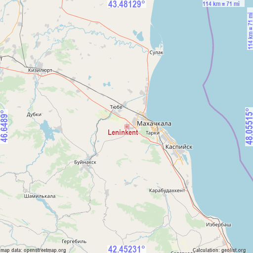
Leninkent GPS coordinates[2]
42° 58' 8.22" North, 47° 21' 7.272" East
| Map corner | latitude | longitude |
|---|---|---|
| Upper-left | 43.48129°, | 46.6489° |
| Center: | 42.96895°, | 47.35202° |
| Lower-right: | 42.45231°, | 48.05515° |
| Map W x H: | 114.4×114.4 km | = 71.1×71.1mi |
| max Lat: | 73.50819° ⇑97.7% North |
| Leninkent: | 42.96895° |
| min Lat: | ⇓2.3% South 41.28413° |
| min Long | Leninkent | max Long |
| -179.12198° | 47.35202° | 179.35046° |
| W 57.1%⇐ | ⇒42.9% E |
Elevation
Elevation of Leninkent is 112 m = 367 ft, and this is 90.6 m = 297 ft below average elevation for this country.
| Max E: |
2518 m = 8261 ft | 65.7% |
| Avg. | 202.6 m = 665 ft | |
| Leninkent | 112 m = 367 ft | |
Min E: |
-28 m = -92 ft | 34.3% |
See also: Russia elevation on elevation.city.
Geographical zone
Leninkent is located in North temperate zone (between Tropic of Cancer and the Arctic Circle). Distance of this Northern Tropic circle is 2171.8 km =1349.5 mi to South.| Distance of | km | miles | from Leninkent |
|---|---|---|---|
| North Pole | 5229.4 | 3249.4 | to North |
| Arctic Circle | 2623.5 | 1630.2 | to North |
| Tropic Cancer | 2171.8 | 1349.5 | to South |
| Equator | 4777.7 | 2968.7 | to South |


Nearby cities:
15 places around Leninkent: (largest is in red/bold)
• Buynaksk
25.3 km =15.7 mi,  228°
228°
• Chirkey
30.4 km =18.9 mi,  268°
268°
• Kafyr-Kumukh
21.8 km =13.5 mi, 227°
• Kaspiysk
25.3 km =15.7 mi,  112°
112°
• Korkmaskala
7.7 km =4.8 mi,  322°
322°
• Kyakhulay
10.7 km =6.6 mi,  90°
90°
• Makhachkala
12.3 km =7.6 mi, 86°
• Nizhneye Kazanishche
27.7 km =17.2 mi,  214°
214°
• Novyy Khushet
18.6 km =11.6 mi, 114°
• Paraul
25.2 km =15.7 mi,  179°
179°
• Shamkhal
10.1 km =6.3 mi,  353°
353°
• Shamkhal-Termen
8 km =5 mi,  334°
334°
• Tarki
12 km =7.5 mi,  103°
103°
• Tyube
9.6 km =6 mi,  337°
337°
• Uchkent
27.2 km =16.9 mi,  306°
306°
Sources, notices
• [Note1] Compared only with cities in Russia existing in our database
• [Src1] Map data: © OpenStreetMap contributors (CC-BY-SA)
• [Src2] Other city data from geonames.org with taken over terms of usage.
• [Src3] Geographical zone / Annual Mean Temperature by Robert A. Rohde @ Wikipedia
