Kyakhulay geodata
Kyakhulay (Dagestan) is a populated place; located in Russia in Europe/Moscow (GMT+3) time zone. With population of 5,731 people, there are 2353 cities with bigger population in this country. Compared to other cities in Russia, 97.7% of cities are located further ↑North; 57.3% of cities are located further ←West and 90.9% of cities have higher elevation than Kyakhulay. Note1


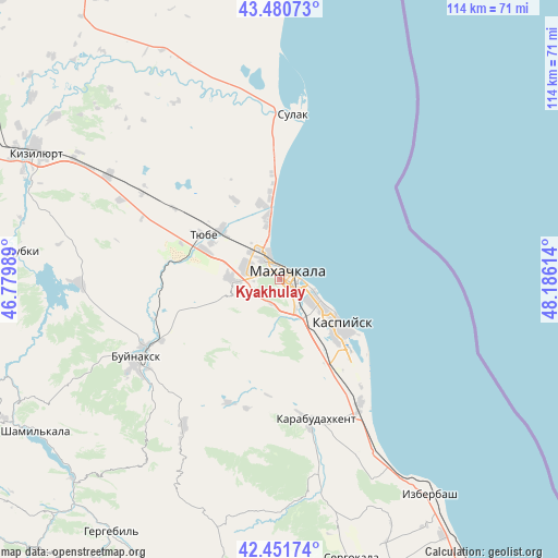
Kyakhulay GPS coordinates[2]
42° 58' 6.204" North, 47° 28' 58.836" East
| Map corner | latitude | longitude |
|---|---|---|
| Upper-left | 43.48073°, | 46.77989° |
| Center: | 42.96839°, | 47.48301° |
| Lower-right: | 42.45174°, | 48.18614° |
| Map W x H: | 114.4×114.4 km | = 71.1×71.1mi |
| max Lat: | 73.50819° ⇑97.7% North |
| Kyakhulay: | 42.96839° |
| min Lat: | ⇓2.3% South 41.28413° |
| min Long | Kyakhulay | max Long |
| -179.12198° | 47.48301° | 179.35046° |
| W 57.3%⇐ | ⇒42.7% E |
Elevation
Elevation of Kyakhulay is 25 m = 82 ft, and this is 177.6 m = 583 ft below average elevation for this country.
| Max E: |
2518 m = 8261 ft | 90.9% |
| Avg. | 202.6 m = 665 ft | |
| Kyakhulay | 25 m = 82 ft | |
Min E: |
-28 m = -92 ft | 9.1% |
See also: Russia elevation on elevation.city.
Geographical zone
Kyakhulay is located in North temperate zone (between Tropic of Cancer and the Arctic Circle). Distance of this Northern Tropic circle is 2171.7 km =1349.4 mi to South.| Distance of | km | miles | from Kyakhulay |
|---|---|---|---|
| North Pole | 5229.4 | 3249.4 | to North |
| Arctic Circle | 2623.5 | 1630.2 | to North |
| Tropic Cancer | 2171.7 | 1349.4 | to South |
| Equator | 4777.6 | 2968.7 | to South |


Nearby cities:
15 places around Kyakhulay: (largest is in red/bold)
• Kafyr-Kumukh
30.5 km =19 mi,  241°
241°
• Karabudakhkent
29.7 km =18.5 mi,  166°
166°
• Kaspiysk
16 km =9.9 mi,  127°
127°
• Korkmaskala
16.5 km =10.3 mi,  291°
291°
• Leninkent
10.7 km =6.6 mi,  270°
270°
• Makhachkala
1.8 km =1.1 mi,  60°
60°
• Manas
31.2 km =19.4 mi,  149°
149°
• Manaskent
30.5 km =19 mi, 146°
• Novyy Khushet
9.9 km =6.2 mi,  140°
140°
• Paraul
27.2 km =16.9 mi,  202°
202°
• Shamkhal
15.6 km =9.7 mi,  310°
310°
• Shamkhal-Termen
15.8 km =9.8 mi,  297°
297°
• Sulak
34 km =21.1 mi,  4°
4°
• Tarki
2.9 km =1.8 mi,  159°
159°
• Tyube
16.9 km =10.5 mi, 302°
Sources, notices
• [Note1] Compared only with cities in Russia existing in our database
• [Src1] Map data: © OpenStreetMap contributors (CC-BY-SA)
• [Src2] Other city data from geonames.org with taken over terms of usage.
• [Src3] Geographical zone / Annual Mean Temperature by Robert A. Rohde @ Wikipedia
