Kalininaul geodata
Kalininaul (Dagestan) is a populated place; located in Russia in Europe/Moscow (GMT+3) time zone. With population of 4,752 people, there are 2759 cities with bigger population in this country. Compared to other cities in Russia, 97.3% of cities are located further ↑North; 54.4% of cities are located further ←West and 94.2% of cities have lower elevation than Kalininaul. Note1


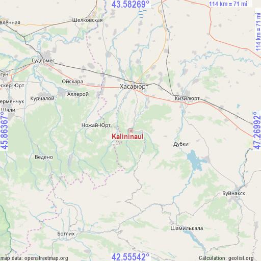
Kalininaul GPS coordinates[2]
43° 4' 16.356" North, 46° 34' 0.444" East
| Map corner | latitude | longitude |
|---|---|---|
| Upper-left | 43.58269°, | 45.86367° |
| Center: | 43.07121°, | 46.56679° |
| Lower-right: | 42.55542°, | 47.26992° |
| Map W x H: | 114.2×114.2 km | = 71×71mi |
| max Lat: | 73.50819° ⇑97.3% North |
| Kalininaul: | 43.07121° |
| min Lat: | ⇓2.7% South 41.28413° |
| min Long | Kalininaul | max Long |
| -179.12198° | 46.56679° | 179.35046° |
| W 54.4%⇐ | ⇒45.6% E |
Elevation
Elevation of Kalininaul is 594 m = 1949 ft, and this is 391.4 m = 1284 ft above average elevation for this country.
| Max E: |
2518 m = 8261 ft | 5.8% |
| Kalininaul | 594 m 1949 ft | |
| Avg. | 202.6 m = 665 ft | |
Min E: |
-28 m = -92 ft | 94.2% |
See also: Russia elevation on elevation.city.
Geographical zone
Kalininaul is located in North temperate zone (between Tropic of Cancer and the Arctic Circle). Distance of this Northern Tropic circle is 2183.2 km =1356.6 mi to South.| Distance of | km | miles | from Kalininaul |
|---|---|---|---|
| North Pole | 5218 | 3242.3 | to North |
| Arctic Circle | 2612.1 | 1623.1 | to North |
| Tropic Cancer | 2183.2 | 1356.6 | to South |
| Equator | 4789.1 | 2975.8 | to South |


Nearby cities:
15 places around Kalininaul: (largest is in red/bold)
• Bavtugay
24.2 km =15 mi,  63°
63°
• Burtunay
10.5 km =6.5 mi,  150°
150°
• Dubki
22.7 km =14.1 mi,  104°
104°
• Dylym
5.5 km =3.4 mi,  90°
90°
• Endirey
12.4 km =7.7 mi,  34°
34°
• Gerzel’-Aul
23.7 km =14.7 mi,  325°
325°
• Ishkhoy-Yurt
21.3 km =13.2 mi,  317°
317°
• Khasavyurt
20.1 km =12.5 mi,  4°
4°
• Kokrek
22.5 km =14 mi,  35°
35°
• Leninaul
2.3 km =1.4 mi,  15°
15°
• Miatli
21.3 km =13.2 mi, 86°
• Novolakskoye
8.7 km =5.4 mi,  308°
308°
• Nozhay-Yurt
15.5 km =9.6 mi,  278°
278°
• Solnechnoye
23.3 km =14.5 mi,  347°
347°
• Zandak
9.2 km =5.7 mi,  260°
260°
Sources, notices
• [Note1] Compared only with cities in Russia existing in our database
• [Src1] Map data: © OpenStreetMap contributors (CC-BY-SA)
• [Src2] Other city data from geonames.org with taken over terms of usage.
• [Src3] Geographical zone / Annual Mean Temperature by Robert A. Rohde @ Wikipedia
