Kuzovatovo geodata
Kuzovatovo (Ulyanovsk) is a populated place; located in Russia in Europe/Ulyanovsk (GMT+4) time zone. With population of 8,607 people, there are 1703 cities with bigger population in this country. Compared to other cities in Russia, 58.4% of cities are located further ↑North; 58.1% of cities are located further ←West and 76.1% of cities have lower elevation than Kuzovatovo. Note1


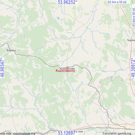
Kuzovatovo GPS coordinates[2]
53° 32' 48.516" North, 47° 41' 11.724" East
| Map corner | latitude | longitude |
|---|---|---|
| Upper-left | 53.96252°, | 46.98347° |
| Center: | 53.54681°, | 47.68659° |
| Lower-right: | 53.12697°, | 48.38972° |
| Map W x H: | 92.9×92.9 km | = 57.7×57.7mi |
| max Lat: | 73.50819° ⇑58.4% North |
| Kuzovatovo: | 53.54681° |
| min Lat: | ⇓41.6% South 41.28413° |
| min Long | Kuzovatovo | max Long |
| -179.12198° | 47.68659° | 179.35046° |
| W 58.1%⇐ | ⇒41.9% E |
Elevation
Elevation of Kuzovatovo is 221 m = 725 ft, and this is 18.4 m = 60 ft above average elevation for this country.
| Max E: |
2518 m = 8261 ft | 23.9% |
| Kuzovatovo | 221 m 725 ft | |
| Avg. | 202.6 m = 665 ft | |
Min E: |
-28 m = -92 ft | 76.1% |
See also: Russia elevation on elevation.city.
Geographical zone
Kuzovatovo is located in North temperate zone (between Tropic of Cancer and the Arctic Circle). Distance of this North polar circle is 1447.3 km =899.3 mi to North.| Distance of | km | miles | from Kuzovatovo |
|---|---|---|---|
| North Pole | 4053.2 | 2518.5 | to North |
| Arctic Circle | 1447.3 | 899.3 | to North |
| Tropic Cancer | 3347.9 | 2080.3 | to South |
| Equator | 5953.8 | 3699.5 | to South |


Nearby cities:
15 places around Kuzovatovo: (largest is in red/bold)
• Balasheyka
39.4 km =24.5 mi,  137°
137°
• Barysh
39.8 km =24.7 mi,  287°
287°
• Chufarovo
65.3 km =40.6 mi,  339°
339°
• Ignatovka
44.6 km =27.7 mi,  357°
357°
• Imeni Vladimira Il’icha Lenina
46.7 km =29 mi,  272°
272°
• Izmaylovo
34.9 km =21.7 mi,  303°
303°
• Kanadey
43.5 km =27 mi,  194°
194°
• Mayna
63.1 km =39.2 mi, 356°
• Nikolayevka
56.7 km =35.2 mi,  214°
214°
• Novospasskoye
44.7 km =27.8 mi,  174°
174°
• Pavlovka
61 km =37.9 mi,  275°
275°
• Silikatnyy
64.8 km =40.3 mi,  40°
40°
• Starotimoshkino
21.7 km =13.5 mi,  331°
331°
• Varlamovo
62.9 km =39.1 mi,  129°
129°
• Zhadovka
48.8 km =30.3 mi, 273°
Sources, notices
• [Note1] Compared only with cities in Russia existing in our database
• [Src1] Map data: © OpenStreetMap contributors (CC-BY-SA)
• [Src2] Other city data from geonames.org with taken over terms of usage.
• [Src3] Geographical zone / Annual Mean Temperature by Robert A. Rohde @ Wikipedia
