Varlamovo geodata
Varlamovo (Samara Oblast) is a populated place; located in Russia in Europe/Samara (GMT+4) time zone. With population of 3,264 people, there are 3555 cities with bigger population in this country. Compared to other cities in Russia, 61.5% of cities are located further ↑North; 60% of cities are located further ←West and 74.6% of cities have higher elevation than Varlamovo. Note1


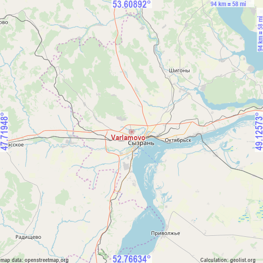
Varlamovo GPS coordinates[2]
53° 11' 22.92" North, 48° 25' 21.36" East
| Map corner | latitude | longitude |
|---|---|---|
| Upper-left | 53.60892°, | 47.71948° |
| Center: | 53.1897°, | 48.4226° |
| Lower-right: | 52.76634°, | 49.12573° |
| Map W x H: | 93.7×93.7 km | = 58.2×58.2mi |
| max Lat: | 73.50819° ⇑61.5% North |
| Varlamovo: | 53.1897° |
| min Lat: | ⇓38.5% South 41.28413° |
| min Long | Varlamovo | max Long |
| -179.12198° | 48.4226° | 179.35046° |
| W 60%⇐ | ⇒40% E |
Elevation
Elevation of Varlamovo is 89 m = 292 ft, and this is 113.6 m = 373 ft below average elevation for this country.
| Max E: |
2518 m = 8261 ft | 74.6% |
| Avg. | 202.6 m = 665 ft | |
| Varlamovo | 89 m = 292 ft | |
Min E: |
-28 m = -92 ft | 25.4% |
See also: Russia elevation on elevation.city.
Geographical zone
Varlamovo is located in North temperate zone (between Tropic of Cancer and the Arctic Circle). Distance of this North polar circle is 1487 km =924 mi to North.| Distance of | km | miles | from Varlamovo |
|---|---|---|---|
| North Pole | 4092.9 | 2543.2 | to North |
| Arctic Circle | 1487 | 924 | to North |
| Tropic Cancer | 3308.2 | 2055.6 | to South |
| Equator | 5914.1 | 3674.9 | to South |


Nearby cities:
15 places around Varlamovo: (largest is in red/bold)
• Balasheyka
24.8 km =15.4 mi,  295°
295°
• Bol’shaya Ryazan’
59.1 km =36.7 mi,  82°
82°
• Kanadey
59.8 km =37.2 mi,  267°
267°
• Kuzovatovo
62.9 km =39.1 mi,  309°
309°
• Mezhdurechensk
46.6 km =29 mi, 79°
• Novospasskoye
45 km =28 mi,  263°
263°
• Obsharovka
29.6 km =18.4 mi,  104°
104°
• Oktyabr’sk
18.7 km =11.6 mi, 97°
• Perevoloki
50.8 km =31.6 mi, 82°
• Podstepki
59.6 km =37 mi,  52°
52°
• Radishchevo
52.2 km =32.4 mi,  224°
224°
• Shigony
27.8 km =17.3 mi,  37°
37°
• Syzran’
4.6 km =2.9 mi,  138°
138°
• Valy
67.1 km =41.7 mi, 77°
• Zhiguli
61.3 km =38.1 mi,  72°
72°
Sources, notices
• [Note1] Compared only with cities in Russia existing in our database
• [Src1] Map data: © OpenStreetMap contributors (CC-BY-SA)
• [Src2] Other city data from geonames.org with taken over terms of usage.
• [Src3] Geographical zone / Annual Mean Temperature by Robert A. Rohde @ Wikipedia
