Bogatoye geodata
Bogatoye (Samara Oblast) is a populated place; located in Russia in Europe/Samara (GMT+4) time zone. With population of 6,391 people, there are 2152 cities with bigger population in this country. Compared to other cities in Russia, 62.5% of cities are located further ↑North; 63.4% of cities are located further ←West and 70.2% of cities have higher elevation than Bogatoye. Note1


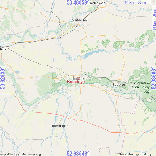
Bogatoye GPS coordinates[2]
53° 3' 36.36" North, 51° 19' 57" East
| Map corner | latitude | longitude |
|---|---|---|
| Upper-left | 53.48059°, | 50.62938° |
| Center: | 53.0601°, | 51.3325° |
| Lower-right: | 52.63546°, | 52.03563° |
| Map W x H: | 94×94 km | = 58.4×58.4mi |
| max Lat: | 73.50819° ⇑62.5% North |
| Bogatoye: | 53.0601° |
| min Lat: | ⇓37.5% South 41.28413° |
| min Long | Bogatoye | max Long |
| -179.12198° | 51.3325° | 179.35046° |
| W 63.4%⇐ | ⇒36.6% E |
Elevation
Elevation of Bogatoye is 102 m = 335 ft, and this is 100.6 m = 330 ft below average elevation for this country.
| Max E: |
2518 m = 8261 ft | 70.2% |
| Avg. | 202.6 m = 665 ft | |
| Bogatoye | 102 m = 335 ft | |
Min E: |
-28 m = -92 ft | 29.8% |
See also: Russia elevation on elevation.city.
Geographical zone
Bogatoye is located in North temperate zone (between Tropic of Cancer and the Arctic Circle). Distance of this North polar circle is 1501.4 km =932.9 mi to North.| Distance of | km | miles | from Bogatoye |
|---|---|---|---|
| North Pole | 4107.3 | 2552.2 | to North |
| Arctic Circle | 1501.4 | 932.9 | to North |
| Tropic Cancer | 3293.8 | 2046.7 | to South |
| Equator | 5899.7 | 3665.9 | to South |


Nearby cities:
15 places around Bogatoye: (largest is in red/bold)
• Borskoye
25.9 km =16.1 mi,  96°
96°
• Buzuluk
69.7 km =43.3 mi,  116°
116°
• Georgiyevka
32.6 km =20.3 mi,  316°
316°
• Kinel’
50.4 km =31.3 mi,  291°
291°
• Kinel’-Cherkassy
46.6 km =29 mi,  11°
11°
• Koltubanovskiy
48.3 km =30 mi,  105°
105°
• Krotovka
27.4 km =17 mi,  336°
336°
• Neftegorsk
30.8 km =19.1 mi,  201°
201°
• Otradnyy
35.1 km =21.8 mi,  1°
1°
• Petra-Dubrava
69.6 km =43.2 mi, 292°
• Podsolnechnoye
46.9 km =29.1 mi,  77°
77°
• Roschinskiy
55.9 km =34.7 mi,  268°
268°
• Smyshlyayevka
65.9 km =40.9 mi, 287°
• Spiridonovka
46 km =28.6 mi, 274°
• Utevka
31 km =19.3 mi,  235°
235°
Sources, notices
• [Note1] Compared only with cities in Russia existing in our database
• [Src1] Map data: © OpenStreetMap contributors (CC-BY-SA)
• [Src2] Other city data from geonames.org with taken over terms of usage.
• [Src3] Geographical zone / Annual Mean Temperature by Robert A. Rohde @ Wikipedia
