Khomutovo geodata
Khomutovo (Orel Oblast) is a populated place; located in Russia in Europe/Moscow (GMT+3) time zone. With population of 4,647 people, there are 2805 cities with bigger population in this country. Compared to other cities in Russia, 63.8% of cities are located further ↑North; 82.5% of cities are located further →East and 80.5% of cities have lower elevation than Khomutovo. Note1


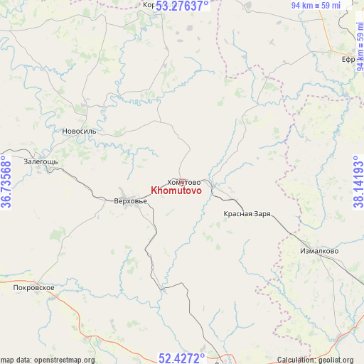
Khomutovo GPS coordinates[2]
52° 51' 13.896" North, 37° 26' 19.68" East
| Map corner | latitude | longitude |
|---|---|---|
| Upper-left | 53.27637°, | 36.73568° |
| Center: | 52.85386°, | 37.4388° |
| Lower-right: | 52.4272°, | 38.14193° |
| Map W x H: | 94.4×94.4 km | = 58.7×58.7mi |
| max Lat: | 73.50819° ⇑63.8% North |
| Khomutovo: | 52.85386° |
| min Lat: | ⇓36.2% South 41.28413° |
| min Long | Khomutovo | max Long |
| -179.12198° | 37.4388° | 179.35046° |
| W 17.5%⇐ | ⇒82.5% E |
Elevation
Elevation of Khomutovo is 252 m = 827 ft, and this is 49.4 m = 162 ft above average elevation for this country.
| Max E: |
2518 m = 8261 ft | 19.5% |
| Khomutovo | 252 m 827 ft | |
| Avg. | 202.6 m = 665 ft | |
Min E: |
-28 m = -92 ft | 80.5% |
See also: Russia elevation on elevation.city.
Geographical zone
Khomutovo is located in North temperate zone (between Tropic of Cancer and the Arctic Circle). Distance of this North polar circle is 1524.4 km =947.2 mi to North.| Distance of | km | miles | from Khomutovo |
|---|---|---|---|
| North Pole | 4130.3 | 2566.4 | to North |
| Arctic Circle | 1524.4 | 947.2 | to North |
| Tropic Cancer | 3270.9 | 2032.4 | to South |
| Equator | 5876.8 | 3651.7 | to South |


Nearby cities:
15 places around Khomutovo: (largest is in red/bold)
• Izmalkovo
39.8 km =24.7 mi,  117°
117°
• Kazachka
70.7 km =43.9 mi,  36°
36°
• Kazaki
61.2 km =38 mi,  114°
114°
• Kolpny
74.7 km =46.4 mi,  201°
201°
• Korsakovo
46.3 km =28.8 mi,  353°
353°
• Krasnaya Zarya
18.1 km =11.2 mi, 116°
• Livny
49 km =30.4 mi,  166°
166°
• Mtsensk
74.5 km =46.3 mi,  309°
309°
• Novosil’
29.9 km =18.6 mi,  296°
296°
• Pokrovskoye
46.9 km =29.1 mi,  234°
234°
• Stanovoye
62.6 km =38.9 mi,  99°
99°
• Verkhov’ye
14 km =8.7 mi,  250°
250°
• Yefremov
55 km =34.2 mi,  53°
53°
• Zalegoshch’
37.1 km =23.1 mi,  277°
277°
• Zmiyëvka
74.6 km =46.4 mi, 253°
Sources, notices
• [Note1] Compared only with cities in Russia existing in our database
• [Src1] Map data: © OpenStreetMap contributors (CC-BY-SA)
• [Src2] Other city data from geonames.org with taken over terms of usage.
• [Src3] Geographical zone / Annual Mean Temperature by Robert A. Rohde @ Wikipedia
