Kletskaya geodata
Kletskaya (Volgograd Oblast) is a populated place; located in Russia in Europe/Volgograd (GMT+3) time zone. With population of 5,362 people, there are 2486 cities with bigger population in this country. Compared to other cities in Russia, 78.6% of cities are located further ↑North; 56.5% of cities are located further →East and 83.7% of cities have higher elevation than Kletskaya. Note1


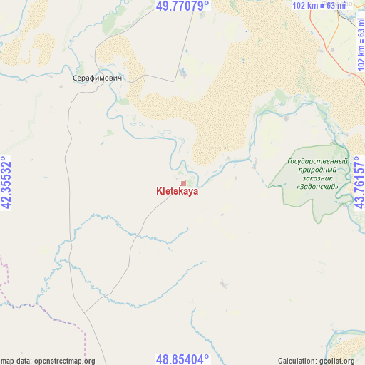
Kletskaya GPS coordinates[2]
49° 18' 52.38" North, 43° 3' 30.384" East
| Map corner | latitude | longitude |
|---|---|---|
| Upper-left | 49.77079°, | 42.35532° |
| Center: | 49.31455°, | 43.05844° |
| Lower-right: | 48.85404°, | 43.76157° |
| Map W x H: | 101.9×101.9 km | = 63.3×63.3mi |
| max Lat: | 73.50819° ⇑78.6% North |
| Kletskaya: | 49.31455° |
| min Lat: | ⇓21.4% South 41.28413° |
| min Long | Kletskaya | max Long |
| -179.12198° | 43.05844° | 179.35046° |
| W 43.5%⇐ | ⇒56.5% E |
Elevation
Elevation of Kletskaya is 54 m = 177 ft, and this is 148.6 m = 488 ft below average elevation for this country.
| Max E: |
2518 m = 8261 ft | 83.7% |
| Avg. | 202.6 m = 665 ft | |
| Kletskaya | 54 m = 177 ft | |
Min E: |
-28 m = -92 ft | 16.3% |
See also: Russia elevation on elevation.city.
Geographical zone
Kletskaya is located in North temperate zone (between Tropic of Cancer and the Arctic Circle). Distance of this North polar circle is 1917.9 km =1191.7 mi to North.| Distance of | km | miles | from Kletskaya |
|---|---|---|---|
| North Pole | 4523.8 | 2811 | to North |
| Arctic Circle | 1917.9 | 1191.7 | to North |
| Tropic Cancer | 2877.3 | 1787.9 | to South |
| Equator | 5483.3 | 3407.2 | to South |


Nearby cities:
15 places around Kletskaya: (largest is in red/bold)
• Bokovskaya
89.6 km =55.7 mi,  263°
263°
• Frolovo
66.9 km =41.6 mi,  40°
40°
• Ilovlya
66.8 km =41.5 mi,  91°
91°
• Kalach-na-Donu
77.3 km =48 mi,  153°
153°
• Kumylzhenskaya
71.5 km =44.4 mi,  331°
331°
• Log
61.1 km =38 mi,  71°
71°
• Mikhaylovka
83.9 km =52.1 mi,  8°
8°
• Novyy Rogachik
101.9 km =63.3 mi,  134°
134°
• Oblivskaya
95.6 km =59.4 mi,  205°
205°
• Oktyabr’skiy
91.3 km =56.7 mi,  143°
143°
• Sebrovo
88.8 km =55.2 mi, 11°
• Serafimovich
37.5 km =23.3 mi,  321°
321°
• Slashchevskaya
79.9 km =49.6 mi, 319°
• Sovetskaya
76.1 km =47.3 mi,  243°
243°
• Surovikino
80.1 km =49.8 mi,  191°
191°
Sources, notices
• [Note1] Compared only with cities in Russia existing in our database
• [Src1] Map data: © OpenStreetMap contributors (CC-BY-SA)
• [Src2] Other city data from geonames.org with taken over terms of usage.
• [Src3] Geographical zone / Annual Mean Temperature by Robert A. Rohde @ Wikipedia
