Kachkanar geodata
Kachkanar (Sverdlovsk) is a populated place; located in Russia in Asia/Yekaterinburg (GMT+5) time zone. With population of 43,983 people, there are 478 cities with bigger population in this country. Compared to other cities in Russia, 85.5% of cities are located further ↓South; 70.7% of cities are located further ←West and 86.8% of cities have lower elevation than Kachkanar. Note1


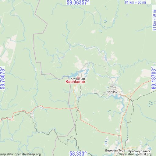
Kachkanar GPS coordinates[2]
58° 42' 0.72" North, 59° 29' 2.04" East
| Map corner | latitude | longitude |
|---|---|---|
| Upper-left | 59.06357°, | 58.78078° |
| Center: | 58.7002°, | 59.4839° |
| Lower-right: | 58.333°, | 60.18703° |
| Map W x H: | 81.2×81.2 km | = 50.5×50.5mi |
| max Lat: | 73.50819° ⇑14.5% North |
| Kachkanar: | 58.7002° |
| min Lat: | ⇓85.5% South 41.28413° |
| min Long | Kachkanar | max Long |
| -179.12198° | 59.4839° | 179.35046° |
| W 70.7%⇐ | ⇒29.3% E |
Elevation
Elevation of Kachkanar is 366 m = 1201 ft, and this is 163.4 m = 536 ft above average elevation for this country.
| Max E: |
2518 m = 8261 ft | 13.2% |
| Kachkanar | 366 m 1201 ft | |
| Avg. | 202.6 m = 665 ft | |
Min E: |
-28 m = -92 ft | 86.8% |
See also: Kachkanar elevation on elevation.city.
Geographical zone
Kachkanar is located in North temperate zone (between Tropic of Cancer and the Arctic Circle). Distance of this North polar circle is 874.3 km =543.3 mi to North.| Distance of | km | miles | from Kachkanar |
|---|---|---|---|
| North Pole | 3480.2 | 2162.5 | to North |
| Arctic Circle | 874.3 | 543.3 | to North |
| Tropic Cancer | 3920.9 | 2436.3 | to South |
| Equator | 6526.9 | 4055.6 | to South |


Nearby cities:
15 places around Kachkanar: (largest is in red/bold)
• Baranchinskiy
61.2 km =38 mi,  168°
168°
• Is
16.9 km =10.5 mi,  53°
53°
• Krasnoural’sk
49.4 km =30.7 mi,  139°
139°
• Kushva
48.3 km =30 mi,  160°
160°
• Lesnoy
19.7 km =12.2 mi,  110°
110°
• Medvedka
22.4 km =13.9 mi,  281°
281°
• Nizhnyaya Tura
20.5 km =12.7 mi, 112°
• Pavda
60.7 km =37.7 mi,  1°
1°
• Promysla
24.4 km =15.2 mi,  231°
231°
• Sarany
41.3 km =25.7 mi,  237°
237°
• Staryy Biser
47.3 km =29.4 mi, 227°
• Tëplaya Gora
30.8 km =19.1 mi, 230°
• Valerianovsk
8 km =5 mi,  32°
32°
• Verkhnyaya Tura
42.1 km =26.2 mi,  153°
153°
• Yëlkino
20.1 km =12.5 mi,  92°
92°
Sources, notices
• [Note1] Compared only with cities in Russia existing in our database
• [Src1] Map data: © OpenStreetMap contributors (CC-BY-SA)
• [Src2] Other city data from geonames.org with taken over terms of usage.
• [Src3] Geographical zone / Annual Mean Temperature by Robert A. Rohde @ Wikipedia
