Is geodata
Is (Sverdlovsk) is a populated place; located in Russia in Asia/Yekaterinburg (GMT+5) time zone. With population of 4,729 people, there are 2768 cities with bigger population in this country. Compared to other cities in Russia, 85.9% of cities are located further ↓South; 71% of cities are located further ←West and 68.7% of cities have lower elevation than Is. Note1


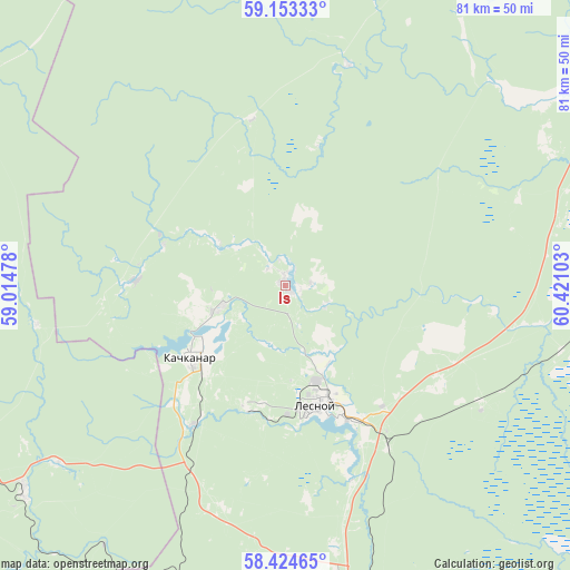
Is GPS coordinates[2]
58° 47' 27.24" North, 59° 43' 4.44" East
| Map corner | latitude | longitude |
|---|---|---|
| Upper-left | 59.15333°, | 59.01478° |
| Center: | 58.7909°, | 59.7179° |
| Lower-right: | 58.42465°, | 60.42103° |
| Map W x H: | 81×81 km | = 50.3×50.3mi |
| max Lat: | 73.50819° ⇑14.1% North |
| Is: | 58.7909° |
| min Lat: | ⇓85.9% South 41.28413° |
| min Long | Is | max Long |
| -179.12198° | 59.7179° | 179.35046° |
| W 71%⇐ | ⇒29% E |
Elevation
Elevation of Is is 193 m = 633 ft, and this is 9.6 m = 31 ft below average elevation for this country.
| Max E: |
2518 m = 8261 ft | 31.3% |
| Avg. | 202.6 m = 665 ft | |
| Is | 193 m = 633 ft | |
Min E: |
-28 m = -92 ft | 68.7% |
See also: Russia elevation on elevation.city.
Geographical zone
Is is located in North temperate zone (between Tropic of Cancer and the Arctic Circle). Distance of this North polar circle is 864.2 km =537 mi to North.| Distance of | km | miles | from Is |
|---|---|---|---|
| North Pole | 3470.1 | 2156.2 | to North |
| Arctic Circle | 864.2 | 537 | to North |
| Tropic Cancer | 3931 | 2442.6 | to South |
| Equator | 6536.9 | 4061.8 | to South |


Nearby cities:
15 places around Is: (largest is in red/bold)
• Kachkanar
16.9 km =10.5 mi,  233°
233°
• Krasnoural’sk
51 km =31.7 mi,  158°
158°
• Kushva
55.7 km =34.6 mi,  177°
177°
• Lesnoy
17.8 km =11.1 mi, 164°
• Medvedka
35.9 km =22.3 mi,  261°
261°
• Nizhnyaya Tura
18.8 km =11.7 mi, 163°
• Novaya Lyalya
58.5 km =36.4 mi,  59°
59°
• Pavda
51.9 km =32.2 mi,  347°
347°
• Promysla
41.3 km =25.7 mi, 232°
• Sarany
58.1 km =36.1 mi,  236°
236°
• Tëplaya Gora
47.6 km =29.6 mi, 231°
• Valerianovsk
9.7 km =6 mi,  249°
249°
• Verkhnyaya Tura
48.1 km =29.9 mi,  173°
173°
• Verkhotur’ye
63.1 km =39.2 mi,  82°
82°
• Yëlkino
12.8 km =8 mi,  149°
149°
Sources, notices
• [Note1] Compared only with cities in Russia existing in our database
• [Src1] Map data: © OpenStreetMap contributors (CC-BY-SA)
• [Src2] Other city data from geonames.org with taken over terms of usage.
• [Src3] Geographical zone / Annual Mean Temperature by Robert A. Rohde @ Wikipedia
