Novaya Lyalya geodata
Novaya Lyalya (Sverdlovsk) is a populated place; located in Russia in Asia/Yekaterinburg (GMT+5) time zone. With population of 14,246 people, there are 1127 cities with bigger population in this country. Compared to other cities in Russia, 86.6% of cities are located further ↓South; 72.7% of cities are located further ←West and 71.5% of cities have higher elevation than Novaya Lyalya. Note1


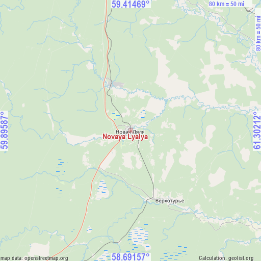
Novaya Lyalya GPS coordinates[2]
59° 3' 18.108" North, 60° 35' 56.364" East
| Map corner | latitude | longitude |
|---|---|---|
| Upper-left | 59.41469°, | 59.89587° |
| Center: | 59.05503°, | 60.59899° |
| Lower-right: | 58.69157°, | 61.30212° |
| Map W x H: | 80.4×80.4 km | = 50×50mi |
| max Lat: | 73.50819° ⇑13.4% North |
| Novaya Lyalya: | 59.05503° |
| min Lat: | ⇓86.6% South 41.28413° |
| min Long | Novaya Lyalya | max Long |
| -179.12198° | 60.59899° | 179.35046° |
| W 72.7%⇐ | ⇒27.3% E |
Elevation
Elevation of Novaya Lyalya is 99 m = 325 ft, and this is 103.6 m = 340 ft below average elevation for this country.
| Max E: |
2518 m = 8261 ft | 71.5% |
| Avg. | 202.6 m = 665 ft | |
| Novaya Lyalya | 99 m = 325 ft | |
Min E: |
-28 m = -92 ft | 28.5% |
See also: Russia elevation on elevation.city.
Geographical zone
Novaya Lyalya is located in North temperate zone (between Tropic of Cancer and the Arctic Circle). Distance of this North polar circle is 834.9 km =518.8 mi to North.| Distance of | km | miles | from Novaya Lyalya |
|---|---|---|---|
| North Pole | 3440.8 | 2138 | to North |
| Arctic Circle | 834.9 | 518.8 | to North |
| Tropic Cancer | 3960.4 | 2460.9 | to South |
| Equator | 6566.3 | 4080.1 | to South |


Nearby cities:
15 places around Novaya Lyalya: (largest is in red/bold)
• Is
58.5 km =36.4 mi,  239°
239°
• Kachkanar
75.3 km =46.8 mi, 238°
• Karpuninskiy
78.5 km =48.8 mi,  118°
118°
• Lesnoy
65.3 km =40.6 mi,  224°
224°
• Lobva
15.2 km =9.4 mi,  342°
342°
• Nizhnyaya Tura
65.5 km =40.7 mi, 223°
• Pavda
65.3 km =40.6 mi,  288°
288°
• Rudnichnyy
74 km =46 mi,  346°
346°
• Serov
61 km =37.9 mi,  358°
358°
• Sos’va
73 km =45.4 mi,  79°
79°
• Valerianovsk
68.1 km =42.3 mi, 241°
• Verkhotur’ye
24.4 km =15.2 mi,  151°
151°
• Vorontsovka
70.1 km =43.6 mi, 343°
• Vostochnyy
75.3 km =46.8 mi,  112°
112°
• Yëlkino
59.8 km =37.2 mi,  227°
227°
Sources, notices
• [Note1] Compared only with cities in Russia existing in our database
• [Src1] Map data: © OpenStreetMap contributors (CC-BY-SA)
• [Src2] Other city data from geonames.org with taken over terms of usage.
• [Src3] Geographical zone / Annual Mean Temperature by Robert A. Rohde @ Wikipedia
