Gornyy Balykley geodata
Gornyy Balykley (Volgograd Oblast) is a populated place; located in Russia in Europe/Volgograd (GMT+3) time zone. With population of 2,656 people, there are 3904 cities with bigger population in this country. Compared to other cities in Russia, 78.6% of cities are located further ↑North; 50.4% of cities are located further ←West and 83.8% of cities have higher elevation than Gornyy Balykley. Note1


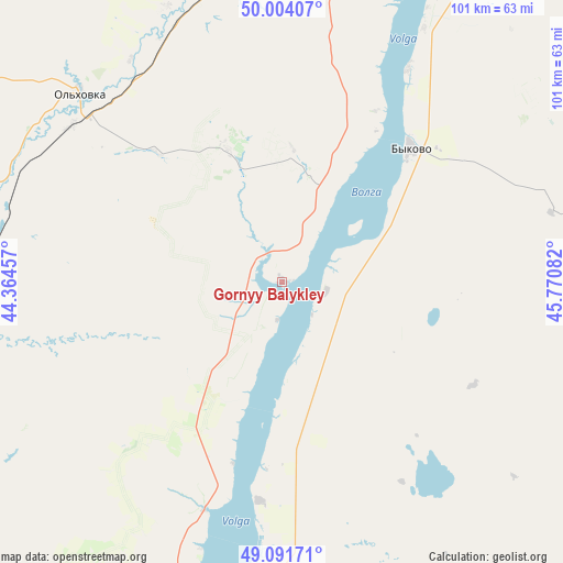
Gornyy Balykley GPS coordinates[2]
49° 33' 0.072" North, 45° 4' 3.684" East
| Map corner | latitude | longitude |
|---|---|---|
| Upper-left | 50.00407°, | 44.36457° |
| Center: | 49.55002°, | 45.06769° |
| Lower-right: | 49.09171°, | 45.77082° |
| Map W x H: | 101.4×101.4 km | = 63×63mi |
| max Lat: | 73.50819° ⇑78.6% North |
| Gornyy Balykley: | 49.55002° |
| min Lat: | ⇓21.4% South 41.28413° |
| min Long | Gornyy Balykley | max Long |
| -179.12198° | 45.06769° | 179.35046° |
| W 50.4%⇐ | ⇒49.6% E |
Elevation
Elevation of Gornyy Balykley is 53 m = 174 ft, and this is 149.6 m = 491 ft below average elevation for this country.
| Max E: |
2518 m = 8261 ft | 83.8% |
| Avg. | 202.6 m = 665 ft | |
| Gornyy Balykley | 53 m = 174 ft | |
Min E: |
-28 m = -92 ft | 16.2% |
See also: Russia elevation on elevation.city.
Geographical zone
Gornyy Balykley is located in North temperate zone (between Tropic of Cancer and the Arctic Circle). Distance of this North polar circle is 1891.7 km =1175.4 mi to North.| Distance of | km | miles | from Gornyy Balykley |
|---|---|---|---|
| North Pole | 4497.6 | 2794.7 | to North |
| Arctic Circle | 1891.7 | 1175.4 | to North |
| Tropic Cancer | 2903.5 | 1804.2 | to South |
| Equator | 5509.4 | 3423.4 | to South |


Nearby cities:
15 places around Gornyy Balykley: (largest is in red/bold)
• Antipovka
35.7 km =22.2 mi,  29°
29°
• Bykovo
33.3 km =20.7 mi,  43°
43°
• Dubovka
57.4 km =35.7 mi,  197°
197°
• Gorodishche
93.4 km =58 mi,  207°
207°
• Ilovlya
83.3 km =51.8 mi,  250°
250°
• Kamyshin
65.9 km =40.9 mi,  22°
22°
• Kotovo
87.8 km =54.6 mi,  347°
347°
• Log
87.4 km =54.3 mi,  265°
265°
• Nikolayevsk
60.2 km =37.4 mi, 27°
• Petrov Val
66.8 km =41.5 mi,  8°
8°
• Primorsk
31.8 km =19.8 mi,  185°
185°
• Srednyaya Akhtuba
94.5 km =58.7 mi, 188°
• Vodstroy
87 km =54.1 mi, 205°
• Volzhskiy
87.5 km =54.4 mi, 193°
• Zaplavnoye
94 km =58.4 mi,  181°
181°
Sources, notices
• [Note1] Compared only with cities in Russia existing in our database
• [Src1] Map data: © OpenStreetMap contributors (CC-BY-SA)
• [Src2] Other city data from geonames.org with taken over terms of usage.
• [Src3] Geographical zone / Annual Mean Temperature by Robert A. Rohde @ Wikipedia
