Millerovo geodata
Millerovo (Rostov) is a seat of a second-order administrative division; located in Russia in Europe/Moscow (GMT+3) time zone. With population of 38,527 people, there are 542 cities with bigger population in this country. Compared to other cities in Russia, 79.2% of cities are located further ↑North; 65.5% of cities are located further →East and 56.2% of cities have higher elevation than Millerovo. Note1


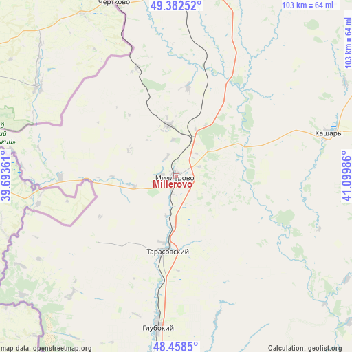
Millerovo GPS coordinates[2]
48° 55' 21.54" North, 40° 23' 48.228" East
| Map corner | latitude | longitude |
|---|---|---|
| Upper-left | 49.38252°, | 39.69361° |
| Center: | 48.92265°, | 40.39673° |
| Lower-right: | 48.4585°, | 41.09986° |
| Map W x H: | 102.7×102.7 km | = 63.8×63.8mi |
| max Lat: | 73.50819° ⇑79.2% North |
| Millerovo: | 48.92265° |
| min Lat: | ⇓20.8% South 41.28413° |
| min Long | Millerovo | max Long |
| -179.12198° | 40.39673° | 179.35046° |
| W 34.5%⇐ | ⇒65.5% E |
Elevation
Elevation of Millerovo is 132 m = 433 ft, and this is 70.6 m = 232 ft below average elevation for this country.
| Max E: |
2518 m = 8261 ft | 56.2% |
| Avg. | 202.6 m = 665 ft | |
| Millerovo | 132 m = 433 ft | |
Min E: |
-28 m = -92 ft | 43.8% |
See also: Russia elevation on elevation.city.
Geographical zone
Millerovo is located in North temperate zone (between Tropic of Cancer and the Arctic Circle). Distance of this North polar circle is 1961.5 km =1218.8 mi to North.| Distance of | km | miles | from Millerovo |
|---|---|---|---|
| North Pole | 4567.4 | 2838 | to North |
| Arctic Circle | 1961.5 | 1218.8 | to North |
| Tropic Cancer | 2833.8 | 1760.8 | to South |
| Equator | 5439.7 | 3380.1 | to South |


Nearby cities:
15 places around Millerovo: (largest is in red/bold)
• Belaya Kalitva
86.5 km =53.7 mi,  161°
161°
• Chertkovo
54.5 km =33.9 mi,  340°
340°
• Donetsk
72.4 km =45 mi,  206°
206°
• Glubokiy
44.2 km =27.5 mi,  186°
186°
• Gornyatskiy
79.7 km =49.5 mi,  150°
150°
• Kamensk-Shakhtinskiy
68 km =42.3 mi, 188°
• Kashary
46.3 km =28.8 mi,  73°
73°
• Koksovyy
82.7 km =51.4 mi,  167°
167°
• Krasnovka
25.1 km =15.6 mi,  242°
242°
• Likhovskoy
87.2 km =54.2 mi, 190°
• Likhoy
89.6 km =55.7 mi, 189°
• Masalovka
58.6 km =36.4 mi, 189°
• Sholokhovskiy
85.9 km =53.4 mi, 146°
• Staraya Stanitsa
64.6 km =40.1 mi, 186°
• Tarasovskiy
21.9 km =13.6 mi, 186°
Sources, notices
• [Note1] Compared only with cities in Russia existing in our database
• [Src1] Map data: © OpenStreetMap contributors (CC-BY-SA)
• [Src2] Other city data from geonames.org with taken over terms of usage.
• [Src3] Geographical zone / Annual Mean Temperature by Robert A. Rohde @ Wikipedia
