Ferapontovo geodata
Ferapontovo (Vologda) is a populated place; located in Russia in Europe/Moscow (GMT+3) time zone. With population of 4,000 people, there are 3113 cities with bigger population in this country. Compared to other cities in Russia, 89.9% of cities are located further ↓South; 74.1% of cities are located further →East and 55.6% of cities have higher elevation than Ferapontovo. Note1


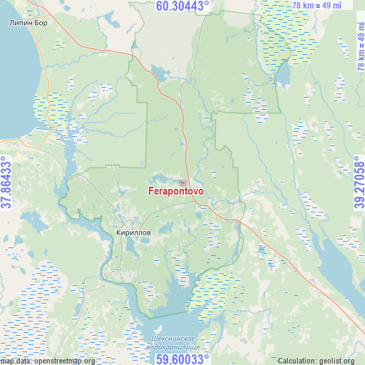
Ferapontovo GPS coordinates[2]
59° 57' 15.3" North, 38° 34' 2.82" East
| Map corner | latitude | longitude |
|---|---|---|
| Upper-left | 60.30443°, | 37.86433° |
| Center: | 59.95425°, | 38.56745° |
| Lower-right: | 59.60033°, | 39.27058° |
| Map W x H: | 78.3×78.3 km | = 48.7×48.7mi |
| max Lat: | 73.50819° ⇑10.1% North |
| Ferapontovo: | 59.95425° |
| min Lat: | ⇓89.9% South 41.28413° |
| min Long | Ferapontovo | max Long |
| -179.12198° | 38.56745° | 179.35046° |
| W 25.9%⇐ | ⇒74.1% E |
Elevation
Elevation of Ferapontovo is 133 m = 436 ft, and this is 69.6 m = 228 ft below average elevation for this country.
| Max E: |
2518 m = 8261 ft | 55.6% |
| Avg. | 202.6 m = 665 ft | |
| Ferapontovo | 133 m = 436 ft | |
Min E: |
-28 m = -92 ft | 44.4% |
See also: Russia elevation on elevation.city.
Geographical zone
Ferapontovo is located in North temperate zone (between Tropic of Cancer and the Arctic Circle). Distance of this North polar circle is 734.9 km =456.6 mi to North.| Distance of | km | miles | from Ferapontovo |
|---|---|---|---|
| North Pole | 3340.8 | 2075.9 | to North |
| Arctic Circle | 734.9 | 456.6 | to North |
| Tropic Cancer | 4060.4 | 2523 | to South |
| Equator | 6666.3 | 4142.2 | to South |


Nearby cities:
15 places around Ferapontovo: (largest is in red/bold)
• Belozërsk
43 km =26.7 mi,  281°
281°
• Chebsara
85.2 km =52.9 mi,  169°
169°
• Cherepovets
98.7 km =61.3 mi,  202°
202°
• Goritsy
19.6 km =12.2 mi,  241°
241°
• Kharovsk
90.4 km =56.2 mi,  89°
89°
• Kirillov
14.5 km =9 mi,  225°
225°
• Kuzino
24.4 km =15.2 mi,  216°
216°
• Lipin Bor
47.4 km =29.5 mi,  316°
316°
• Molochnoye
96.6 km =60 mi,  139°
139°
• Nelazskoye
99.8 km =62 mi,  211°
211°
• Sheksna
82.8 km =51.4 mi,  182°
182°
• Sokol
102.9 km =63.9 mi,  122°
122°
• Tonshalovo
91.4 km =56.8 mi, 202°
• Ust’ye
74.6 km =46.4 mi, 118°
• Zubovo
97.2 km =60.4 mi,  294°
294°
Sources, notices
• [Note1] Compared only with cities in Russia existing in our database
• [Src1] Map data: © OpenStreetMap contributors (CC-BY-SA)
• [Src2] Other city data from geonames.org with taken over terms of usage.
• [Src3] Geographical zone / Annual Mean Temperature by Robert A. Rohde @ Wikipedia
