Lipin Bor geodata
Lipin Bor (Vologda) is a populated place; located in Russia in Europe/Moscow (GMT+3) time zone. With population of 3,771 people, there are 3232 cities with bigger population in this country. Compared to other cities in Russia, 91.5% of cities are located further ↓South; 77.4% of cities are located further →East and 55.6% of cities have higher elevation than Lipin Bor. Note1


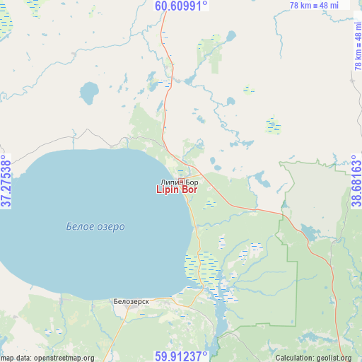
Lipin Bor GPS coordinates[2]
60° 15' 46.8" North, 37° 58' 42.6" East
| Map corner | latitude | longitude |
|---|---|---|
| Upper-left | 60.60991°, | 37.27538° |
| Center: | 60.263°, | 37.9785° |
| Lower-right: | 59.91237°, | 38.68163° |
| Map W x H: | 77.6×77.6 km | = 48.2×48.2mi |
| max Lat: | 73.50819° ⇑8.5% North |
| Lipin Bor: | 60.263° |
| min Lat: | ⇓91.5% South 41.28413° |
| min Long | Lipin Bor | max Long |
| -179.12198° | 37.9785° | 179.35046° |
| W 22.6%⇐ | ⇒77.4% E |
Elevation
Elevation of Lipin Bor is 133 m = 436 ft, and this is 69.6 m = 228 ft below average elevation for this country.
| Max E: |
2518 m = 8261 ft | 55.6% |
| Avg. | 202.6 m = 665 ft | |
| Lipin Bor | 133 m = 436 ft | |
Min E: |
-28 m = -92 ft | 44.4% |
See also: Russia elevation on elevation.city.
Geographical zone
Lipin Bor is located in North temperate zone (between Tropic of Cancer and the Arctic Circle). Distance of this North polar circle is 700.6 km =435.3 mi to North.| Distance of | km | miles | from Lipin Bor |
|---|---|---|---|
| North Pole | 3306.4 | 2054.5 | to North |
| Arctic Circle | 700.6 | 435.3 | to North |
| Tropic Cancer | 4094.7 | 2544.3 | to South |
| Equator | 6700.6 | 4163.6 | to South |


Nearby cities:
15 places around Lipin Bor: (largest is in red/bold)
• Belozërsk
27.7 km =17.2 mi,  199°
199°
• Cherepovets
125.7 km =78.1 mi,  182°
182°
• Ferapontovo
47.4 km =29.5 mi,  136°
136°
• Goritsy
46.5 km =28.9 mi,  160°
160°
• Kharovsk
127 km =78.9 mi,  105°
105°
• Kirillov
49.8 km =30.9 mi,  153°
153°
• Kuzino
57.1 km =35.5 mi, 161°
• Nelazskoye
120.9 km =75.1 mi,  189°
189°
• Sheksna
120.8 km =75.1 mi,  165°
165°
• Suda
125.7 km =78.1 mi, 190°
• Tonshalovo
118.8 km =73.8 mi, 180°
• Ust’ye
120.5 km =74.9 mi,  125°
125°
• Vozhega
125.5 km =78 mi,  79°
79°
• Vytegra
117.4 km =72.9 mi,  314°
314°
• Zubovo
55.9 km =34.7 mi,  276°
276°
Sources, notices
• [Note1] Compared only with cities in Russia existing in our database
• [Src1] Map data: © OpenStreetMap contributors (CC-BY-SA)
• [Src2] Other city data from geonames.org with taken over terms of usage.
• [Src3] Geographical zone / Annual Mean Temperature by Robert A. Rohde @ Wikipedia
