Belozërsk geodata
Belozërsk (Vologda) is a populated place; located in Russia in Europe/Moscow (GMT+3) time zone. With population of 11,049 people, there are 1369 cities with bigger population in this country. Compared to other cities in Russia, 90.6% of cities are located further ↓South; 78.8% of cities are located further →East and 56.6% of cities have higher elevation than Belozërsk. Note1


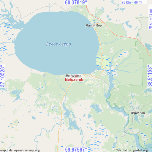
Belozërsk GPS coordinates[2]
60° 1' 43.68" North, 37° 48' 30.24" East
| Map corner | latitude | longitude |
|---|---|---|
| Upper-left | 60.37819°, | 37.10528° |
| Center: | 60.0288°, | 37.8084° |
| Lower-right: | 59.67567°, | 38.51153° |
| Map W x H: | 78.1×78.1 km | = 48.5×48.5mi |
| max Lat: | 73.50819° ⇑9.4% North |
| Belozërsk: | 60.0288° |
| min Lat: | ⇓90.6% South 41.28413° |
| min Long | Belozërsk | max Long |
| -179.12198° | 37.8084° | 179.35046° |
| W 21.2%⇐ | ⇒78.8% E |
Elevation
Elevation of Belozërsk is 131 m = 430 ft, and this is 71.6 m = 235 ft below average elevation for this country.
| Max E: |
2518 m = 8261 ft | 56.6% |
| Avg. | 202.6 m = 665 ft | |
| Belozërsk | 131 m = 430 ft | |
Min E: |
-28 m = -92 ft | 43.4% |
See also: Russia elevation on elevation.city.
Geographical zone
Belozërsk is located in North temperate zone (between Tropic of Cancer and the Arctic Circle). Distance of this North polar circle is 726.6 km =451.5 mi to North.| Distance of | km | miles | from Belozërsk |
|---|---|---|---|
| North Pole | 3332.5 | 2070.7 | to North |
| Arctic Circle | 726.6 | 451.5 | to North |
| Tropic Cancer | 4068.7 | 2528.2 | to South |
| Equator | 6674.6 | 4147.4 | to South |


Nearby cities:
15 places around Belozërsk: (largest is in red/bold)
• Chebsara
108.7 km =67.5 mi,  147°
147°
• Cherepovets
99.7 km =62 mi,  177°
177°
• Ferapontovo
43 km =26.7 mi,  101°
101°
• Goritsy
30.8 km =19.1 mi,  125°
125°
• Kaduy
99.3 km =61.7 mi,  201°
201°
• Khokhlovo
100.5 km =62.4 mi,  193°
193°
• Kirillov
36.8 km =22.9 mi,  120°
120°
• Kuzino
39.6 km =24.6 mi,  135°
135°
• Lipin Bor
27.7 km =17.2 mi,  19°
19°
• Nelazskoye
93.8 km =58.3 mi, 185°
• Sheksna
99.2 km =61.6 mi,  156°
156°
• Suda
98.4 km =61.1 mi, 188°
• Tonshalovo
93.1 km =57.8 mi, 175°
• Ust’ye
116.5 km =72.4 mi,  112°
112°
• Zubovo
56.4 km =35 mi,  304°
304°
Sources, notices
• [Note1] Compared only with cities in Russia existing in our database
• [Src1] Map data: © OpenStreetMap contributors (CC-BY-SA)
• [Src2] Other city data from geonames.org with taken over terms of usage.
• [Src3] Geographical zone / Annual Mean Temperature by Robert A. Rohde @ Wikipedia
