Chernoyerkovskaya geodata
Chernoyerkovskaya (Krasnodarskiy) is a populated place; located in Russia in Europe/Moscow (GMT+3) time zone. With population of 3,856 people, there are 3188 cities with bigger population in this country. Compared to other cities in Russia, 85.4% of cities are located further ↑North; 79.1% of cities are located further →East and 98.8% of cities have higher elevation than Chernoyerkovskaya. Note1


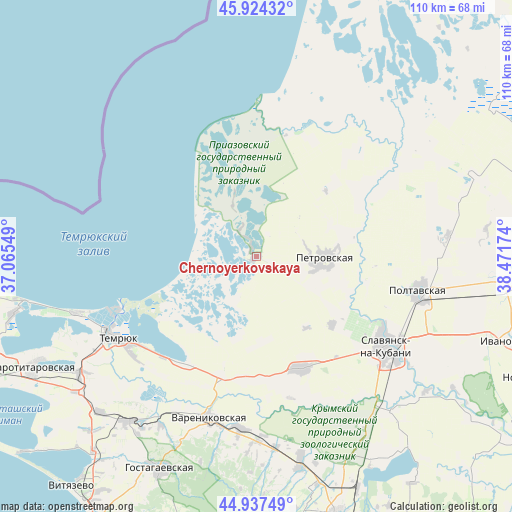
Chernoyerkovskaya GPS coordinates[2]
45° 25' 59.016" North, 37° 46' 6.996" East
| Map corner | latitude | longitude |
|---|---|---|
| Upper-left | 45.92432°, | 37.06549° |
| Center: | 45.43306°, | 37.76861° |
| Lower-right: | 44.93749°, | 38.47174° |
| Map W x H: | 109.7×109.7 km | = 68.2×68.2mi |
| max Lat: | 73.50819° ⇑85.4% North |
| Chernoyerkovskaya: | 45.43306° |
| min Lat: | ⇓14.6% South 41.28413° |
| min Long | Chernoyerkovska | max Long |
| -179.12198° | 37.76861° | 179.35046° |
| W 20.9%⇐ | ⇒79.1% E |
Elevation
Elevation of Chernoyerkovskaya is 1 m = 3 ft, and this is 201.6 m = 661 ft below average elevation for this country.
| Max E: |
2518 m = 8261 ft | 98.8% |
| Avg. | 202.6 m = 665 ft | |
| Chernoyerkovskaya | 1 m = 3 ft | |
Min E: |
-28 m = -92 ft | 1.2% |
See also: Russia elevation on elevation.city.
Geographical zone
Chernoyerkovskaya is located in North temperate zone (between Tropic of Cancer and the Arctic Circle). Distance of this North polar circle is 2349.5 km =1459.9 mi to North.| Distance of | km | miles | from Chernoyerkovskaya |
|---|---|---|---|
| North Pole | 4955.4 | 3079.1 | to North |
| Arctic Circle | 2349.5 | 1459.9 | to North |
| Tropic Cancer | 2445.8 | 1519.7 | to South |
| Equator | 5051.7 | 3139 | to South |


Nearby cities:
15 places around Chernoyerkovskaya: (largest is in red/bold)
• Anastasiyevskaya
26 km =16.2 mi,  158°
158°
• Golubitskaya
40.7 km =25.3 mi,  252°
252°
• Grivenskaya
39.7 km =24.7 mi,  53°
53°
• Kiyevskoye
44.9 km =27.9 mi,  167°
167°
• Korzhevskiy
26.8 km =16.7 mi,  188°
188°
• Krasnoarmeyskaya
35.4 km =22 mi,  102°
102°
• Petrovskaya
14.5 km =9 mi,  90°
90°
• Slavyansk-na-Kubani
34.2 km =21.3 mi,  125°
125°
• Sovkhoznyy
31.1 km =19.3 mi,  119°
119°
• Starodzhereliyevskaya
41.5 km =25.8 mi,  83°
83°
• Temryuk
34.9 km =21.7 mi,  238°
238°
• Troitskaya
43.3 km =26.9 mi,  139°
139°
• Trudobelikovskiy
35.2 km =21.9 mi, 121°
• Varenikovskaya
36.1 km =22.4 mi,  195°
195°
• Yurovka
44.7 km =27.8 mi,  217°
217°
Sources, notices
• [Note1] Compared only with cities in Russia existing in our database
• [Src1] Map data: © OpenStreetMap contributors (CC-BY-SA)
• [Src2] Other city data from geonames.org with taken over terms of usage.
• [Src3] Geographical zone / Annual Mean Temperature by Robert A. Rohde @ Wikipedia
