Sovkhoznyy geodata
Sovkhoznyy (Krasnodarskiy) is a populated place; located in Russia in Europe/Moscow (GMT+3) time zone. With population of 3,916 people, there are 3160 cities with bigger population in this country. Compared to other cities in Russia, 86.1% of cities are located further ↑North; 76.5% of cities are located further →East and 97.8% of cities have higher elevation than Sovkhoznyy. Note1


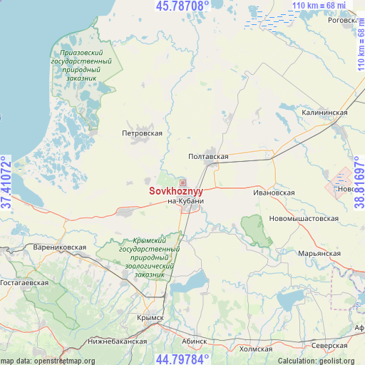
Sovkhoznyy GPS coordinates[2]
45° 17' 40.632" North, 38° 6' 49.824" East
| Map corner | latitude | longitude |
|---|---|---|
| Upper-left | 45.78708°, | 37.41072° |
| Center: | 45.29462°, | 38.11384° |
| Lower-right: | 44.79784°, | 38.81697° |
| Map W x H: | 110×110 km | = 68.4×68.4mi |
| max Lat: | 73.50819° ⇑86.1% North |
| Sovkhoznyy: | 45.29462° |
| min Lat: | ⇓13.9% South 41.28413° |
| min Long | Sovkhoznyy | max Long |
| -179.12198° | 38.11384° | 179.35046° |
| W 23.5%⇐ | ⇒76.5% E |
Elevation
Elevation of Sovkhoznyy is 5 m = 16 ft, and this is 197.6 m = 648 ft below average elevation for this country.
| Max E: |
2518 m = 8261 ft | 97.8% |
| Avg. | 202.6 m = 665 ft | |
| Sovkhoznyy | 5 m = 16 ft | |
Min E: |
-28 m = -92 ft | 2.2% |
See also: Russia elevation on elevation.city.
Geographical zone
Sovkhoznyy is located in North temperate zone (between Tropic of Cancer and the Arctic Circle). Distance of this North polar circle is 2364.9 km =1469.5 mi to North.| Distance of | km | miles | from Sovkhoznyy |
|---|---|---|---|
| North Pole | 4970.8 | 3088.7 | to North |
| Arctic Circle | 2364.9 | 1469.5 | to North |
| Tropic Cancer | 2430.4 | 1510.2 | to South |
| Equator | 5036.3 | 3129.4 | to South |


Nearby cities:
15 places around Sovkhoznyy: (largest is in red/bold)
• Anastasiyevskaya
19.4 km =12.1 mi,  243°
243°
• Chernoyerkovskaya
31.1 km =19.3 mi,  299°
299°
• Grivenskaya
39.5 km =24.5 mi,  7°
7°
• Kiyevskoye
33.5 km =20.8 mi,  211°
211°
• Korzhevskiy
32.8 km =20.4 mi,  250°
250°
• Krasnoarmeyskaya
11 km =6.8 mi,  43°
43°
• Krymsk
41.7 km =25.9 mi,  193°
193°
• Novomyshastovskaya
38.2 km =23.7 mi,  106°
106°
• Petrovskaya
19.6 km =12.2 mi,  320°
320°
• Slavyansk-na-Kubani
4.4 km =2.7 mi,  167°
167°
• Starodzhereliyevskaya
24.7 km =15.3 mi, 35°
• Staronizhestebliyevskaya
27.5 km =17.1 mi,  69°
69°
• Troitskaya
17.8 km =11.1 mi,  177°
177°
• Trudobelikovskiy
4.3 km =2.7 mi,  132°
132°
• Varenikovskaya
41.7 km =25.9 mi, 242°
Sources, notices
• [Note1] Compared only with cities in Russia existing in our database
• [Src1] Map data: © OpenStreetMap contributors (CC-BY-SA)
• [Src2] Other city data from geonames.org with taken over terms of usage.
• [Src3] Geographical zone / Annual Mean Temperature by Robert A. Rohde @ Wikipedia
