Birsk geodata
Birsk (Bashkortostan Republic) is a populated place; located in Russia in Asia/Yekaterinburg (GMT+5) time zone. With population of 41,014 people, there are 513 cities with bigger population in this country. Compared to other cities in Russia, 57.3% of cities are located further ↓South; 67% of cities are located further ←West and 52.4% of cities have lower elevation than Birsk. Note1


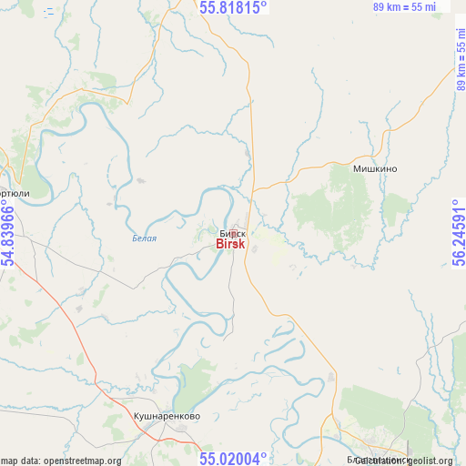
Birsk GPS coordinates[2]
55° 25' 15.996" North, 55° 32' 34.008" East
| Map corner | latitude | longitude |
|---|---|---|
| Upper-left | 55.81815°, | 54.83966° |
| Center: | 55.42111°, | 55.54278° |
| Lower-right: | 55.02004°, | 56.24591° |
| Map W x H: | 88.7×88.7 km | = 55.1×55.1mi |
| max Lat: | 73.50819° ⇑42.7% North |
| Birsk: | 55.42111° |
| min Lat: | ⇓57.3% South 41.28413° |
| min Long | Birsk | max Long |
| -179.12198° | 55.54278° | 179.35046° |
| W 67%⇐ | ⇒33% E |
Elevation
Elevation of Birsk is 150 m = 492 ft, and this is 52.6 m = 173 ft below average elevation for this country.
| Max E: |
2518 m = 8261 ft | 47.6% |
| Avg. | 202.6 m = 665 ft | |
| Birsk | 150 m = 492 ft | |
Min E: |
-28 m = -92 ft | 52.4% |
See also: Birsk elevation on elevation.city.
Geographical zone
Birsk is located in North temperate zone (between Tropic of Cancer and the Arctic Circle). Distance of this North polar circle is 1238.9 km =769.8 mi to North.| Distance of | km | miles | from Birsk |
|---|---|---|---|
| North Pole | 3844.8 | 2389 | to North |
| Arctic Circle | 1238.9 | 769.8 | to North |
| Tropic Cancer | 3556.3 | 2209.8 | to South |
| Equator | 6162.2 | 3829 | to South |


Nearby cities:
15 places around Birsk: (largest is in red/bold)
• Alekseyevka
66.5 km =41.3 mi,  197°
197°
• Asanovo
58.7 km =36.5 mi,  183°
183°
• Bedeyeva Polyana
54.5 km =33.9 mi,  101°
101°
• Blagoveshchensk
51 km =31.7 mi,  147°
147°
• Burayevo
47.4 km =29.5 mi,  349°
349°
• Chekmagush
64.7 km =40.2 mi,  240°
240°
• Dyurtyuli
43.2 km =26.8 mi,  280°
280°
• Krasnokholmskiy
70.2 km =43.6 mi,  333°
333°
• Krasnyy Klyuch
70.2 km =43.6 mi,  93°
93°
• Kushnarënkovo
37.2 km =23.1 mi, 199°
• Mikhaylovka
72 km =44.7 mi,  162°
162°
• Pavlovka
63.8 km =39.6 mi, 90°
• Semiletka
59 km =36.7 mi,  263°
263°
• Starobaltachevo
68.9 km =42.8 mi,  20°
20°
• Yazykovo
43.7 km =27.2 mi,  120°
120°
Sources, notices
• [Note1] Compared only with cities in Russia existing in our database
• [Src1] Map data: © OpenStreetMap contributors (CC-BY-SA)
• [Src2] Other city data from geonames.org with taken over terms of usage.
• [Src3] Geographical zone / Annual Mean Temperature by Robert A. Rohde @ Wikipedia
