Belaya geodata
Belaya (Kursk) is a populated place; located in Russia in Europe/Moscow (GMT+3) time zone. With population of 2,810 people, there are 3855 cities with bigger population in this country. Compared to other cities in Russia, 74.7% of cities are located further ↑North; 88% of cities are located further →East and 53.1% of cities have lower elevation than Belaya. Note1


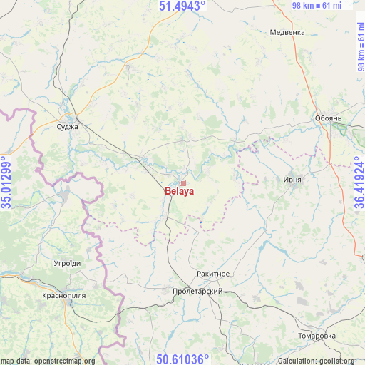
Belaya GPS coordinates[2]
51° 3' 15.984" North, 35° 42' 57.996" East
| Map corner | latitude | longitude |
|---|---|---|
| Upper-left | 51.4943°, | 35.01299° |
| Center: | 51.05444°, | 35.71611° |
| Lower-right: | 50.61036°, | 36.41924° |
| Map W x H: | 98.3×98.3 km | = 61.1×61.1mi |
| max Lat: | 73.50819° ⇑74.7% North |
| Belaya: | 51.05444° |
| min Lat: | ⇓25.3% South 41.28413° |
| min Long | Belaya | max Long |
| -179.12198° | 35.71611° | 179.35046° |
| W 12%⇐ | ⇒88% E |
Elevation
Elevation of Belaya is 152 m = 499 ft, and this is 50.6 m = 166 ft below average elevation for this country.
| Max E: |
2518 m = 8261 ft | 46.9% |
| Avg. | 202.6 m = 665 ft | |
| Belaya | 152 m = 499 ft | |
Min E: |
-28 m = -92 ft | 53.1% |
See also: Russia elevation on elevation.city.
Geographical zone
Belaya is located in North temperate zone (between Tropic of Cancer and the Arctic Circle). Distance of this North polar circle is 1724.5 km =1071.6 mi to North.| Distance of | km | miles | from Belaya |
|---|---|---|---|
| North Pole | 4330.3 | 2690.7 | to North |
| Arctic Circle | 1724.5 | 1071.6 | to North |
| Tropic Cancer | 3070.8 | 1908.1 | to South |
| Equator | 5676.7 | 3527.3 | to South |


Nearby cities:
15 places around Belaya: (largest is in red/bold)
• Borisovka
54.6 km =33.9 mi,  157°
157°
• Chernitsyno
55.5 km =34.5 mi,  24°
24°
• Golovchino
58.1 km =36.1 mi,  174°
174°
• Grayvoron
64.3 km =40 mi,  182°
182°
• Ivanino
66.2 km =41.1 mi,  351°
351°
• Ivnya
29.2 km =18.1 mi,  88°
88°
• Krasnaya Yaruga
28.5 km =17.7 mi,  188°
188°
• Kurchatov
67.5 km =41.9 mi,  356°
356°
• Oboyan’
42.9 km =26.7 mi,  66°
66°
• Proletarskiy
29.5 km =18.3 mi, 172°
• Rakitnoye
25.8 km =16 mi, 158°
• Stroitel’
61.5 km =38.2 mi,  119°
119°
• Sudzha
34.8 km =21.6 mi,  297°
297°
• Tomarovka
54.9 km =34.1 mi,  138°
138°
• Yakovlevo
55.6 km =34.5 mi,  112°
112°
Sources, notices
• [Note1] Compared only with cities in Russia existing in our database
• [Src1] Map data: © OpenStreetMap contributors (CC-BY-SA)
• [Src2] Other city data from geonames.org with taken over terms of usage.
• [Src3] Geographical zone / Annual Mean Temperature by Robert A. Rohde @ Wikipedia
