Stroitel’ geodata
Stroitel’ (Belgorod Oblast) is a populated place; located in Russia in Europe/Moscow (GMT+3) time zone. With population of 18,636 people, there are 922 cities with bigger population in this country. Compared to other cities in Russia, 75.6% of cities are located further ↑North; 86.3% of cities are located further →East and 78.9% of cities have lower elevation than Stroitel’. Note1


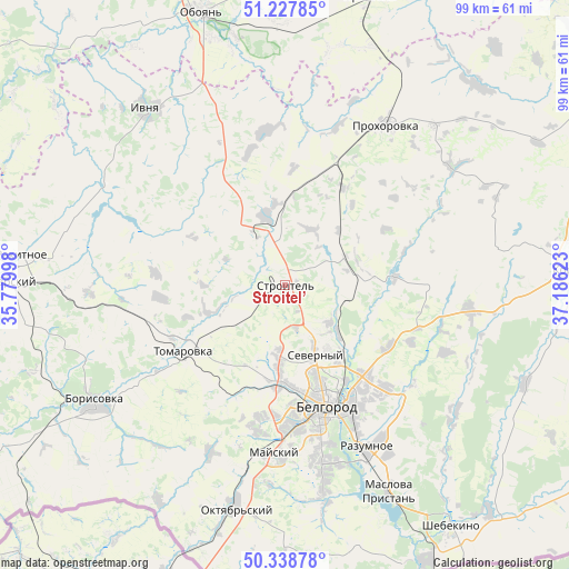
Stroitel’ GPS coordinates[2]
50° 47' 7.548" North, 36° 28' 59.16" East
| Map corner | latitude | longitude |
|---|---|---|
| Upper-left | 51.22785°, | 35.77998° |
| Center: | 50.78543°, | 36.4831° |
| Lower-right: | 50.33878°, | 37.18623° |
| Map W x H: | 98.9×98.9 km | = 61.5×61.5mi |
| max Lat: | 73.50819° ⇑75.6% North |
| Stroitel’: | 50.78543° |
| min Lat: | ⇓24.4% South 41.28413° |
| min Long | Stroitel’ | max Long |
| -179.12198° | 36.4831° | 179.35046° |
| W 13.7%⇐ | ⇒86.3% E |
Elevation
Elevation of Stroitel’ is 240 m = 787 ft, and this is 37.4 m = 123 ft above average elevation for this country.
| Max E: |
2518 m = 8261 ft | 21.1% |
| Stroitel’ | 240 m 787 ft | |
| Avg. | 202.6 m = 665 ft | |
Min E: |
-28 m = -92 ft | 78.9% |
See also: Russia elevation on elevation.city.
Geographical zone
Stroitel’ is located in North temperate zone (between Tropic of Cancer and the Arctic Circle). Distance of this North polar circle is 1754.4 km =1090.1 mi to North.| Distance of | km | miles | from Stroitel’ |
|---|---|---|---|
| North Pole | 4360.3 | 2709.4 | to North |
| Arctic Circle | 1754.4 | 1090.1 | to North |
| Tropic Cancer | 3040.9 | 1889.5 | to South |
| Equator | 5646.8 | 3508.8 | to South |


Nearby cities:
15 places around Stroitel’: (largest is in red/bold)
• Belgorod
20.6 km =12.8 mi,  160°
160°
• Bessonovka
31.5 km =19.6 mi,  204°
204°
• Borisovka
38.8 km =24.1 mi,  238°
238°
• Ivnya
39.4 km =24.5 mi,  321°
321°
• Korocha
49.5 km =30.8 mi,  86°
86°
• Maslova Pristan’
40.1 km =24.9 mi, 155°
• Mayskiy
29.6 km =18.4 mi,  183°
183°
• Oboyan’
49.3 km =30.6 mi,  343°
343°
• Prokhorovka
33 km =20.5 mi,  31°
31°
• Proletarskiy
49.9 km =31 mi,  270°
270°
• Rakitnoye
44.8 km =27.8 mi,  277°
277°
• Razumnoye
31.3 km =19.4 mi,  153°
153°
• Severnyy
13 km =8.1 mi, 157°
• Tomarovka
20.9 km =13 mi, 237°
• Yakovlevo
8.7 km =5.4 mi, 343°
Sources, notices
• [Note1] Compared only with cities in Russia existing in our database
• [Src1] Map data: © OpenStreetMap contributors (CC-BY-SA)
• [Src2] Other city data from geonames.org with taken over terms of usage.
• [Src3] Geographical zone / Annual Mean Temperature by Robert A. Rohde @ Wikipedia
