Tomarovka geodata
Tomarovka (Belgorod Oblast) is a populated place; located in Russia in Europe/Moscow (GMT+3) time zone. With population of 7,916 people, there are 1823 cities with bigger population in this country. Compared to other cities in Russia, 76% of cities are located further ↑North; 86.9% of cities are located further →East and 52.8% of cities have lower elevation than Tomarovka. Note1


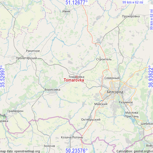
Tomarovka GPS coordinates[2]
50° 41' 0.168" North, 36° 13' 59.124" East
| Map corner | latitude | longitude |
|---|---|---|
| Upper-left | 51.12677°, | 35.52997° |
| Center: | 50.68338°, | 36.23309° |
| Lower-right: | 50.23576°, | 36.93622° |
| Map W x H: | 99.1×99.1 km | = 61.6×61.6mi |
| max Lat: | 73.50819° ⇑76% North |
| Tomarovka: | 50.68338° |
| min Lat: | ⇓24% South 41.28413° |
| min Long | Tomarovka | max Long |
| -179.12198° | 36.23309° | 179.35046° |
| W 13.1%⇐ | ⇒86.9% E |
Elevation
Elevation of Tomarovka is 151 m = 495 ft, and this is 51.6 m = 169 ft below average elevation for this country.
| Max E: |
2518 m = 8261 ft | 47.2% |
| Avg. | 202.6 m = 665 ft | |
| Tomarovka | 151 m = 495 ft | |
Min E: |
-28 m = -92 ft | 52.8% |
See also: Russia elevation on elevation.city.
Geographical zone
Tomarovka is located in North temperate zone (between Tropic of Cancer and the Arctic Circle). Distance of this North polar circle is 1765.7 km =1097.2 mi to North.| Distance of | km | miles | from Tomarovka |
|---|---|---|---|
| North Pole | 4371.6 | 2716.4 | to North |
| Arctic Circle | 1765.7 | 1097.2 | to North |
| Tropic Cancer | 3029.5 | 1882.4 | to South |
| Equator | 5635.5 | 3501.7 | to South |


Nearby cities:
15 places around Tomarovka: (largest is in red/bold)
• Belgorod
25.8 km =16 mi,  108°
108°
• Bessonovka
18.1 km =11.2 mi,  164°
164°
• Borisovka
17.8 km =11.1 mi,  239°
239°
• Golovchino
35 km =21.7 mi, 241°
• Grayvoron
45.5 km =28.3 mi, 239°
• Ivnya
42.8 km =26.6 mi,  350°
350°
• Krasnaya Yaruga
42.5 km =26.4 mi,  287°
287°
• Maslova Pristan’
42.6 km =26.5 mi,  126°
126°
• Mayskiy
24.2 km =15 mi,  138°
138°
• Proletarskiy
34.5 km =21.4 mi, 290°
• Rakitnoye
31.9 km =19.8 mi,  302°
302°
• Razumnoye
35.9 km =22.3 mi,  117°
117°
• Severnyy
22.6 km =14 mi,  91°
91°
• Stroitel’
20.9 km =13 mi,  57°
57°
• Yakovlevo
24.8 km =15.4 mi,  37°
37°
Sources, notices
• [Note1] Compared only with cities in Russia existing in our database
• [Src1] Map data: © OpenStreetMap contributors (CC-BY-SA)
• [Src2] Other city data from geonames.org with taken over terms of usage.
• [Src3] Geographical zone / Annual Mean Temperature by Robert A. Rohde @ Wikipedia
