Krasnoturansk geodata
Krasnoturansk (Krasnoyarskiy) is a populated place; located in Russia in Asia/Krasnoyarsk (GMT+7) time zone. With population of 5,845 people, there are 2317 cities with bigger population in this country. Compared to other cities in Russia, 52.7% of cities are located further ↑North; 86.2% of cities are located further ←West and 85.1% of cities have lower elevation than Krasnoturansk. Note1


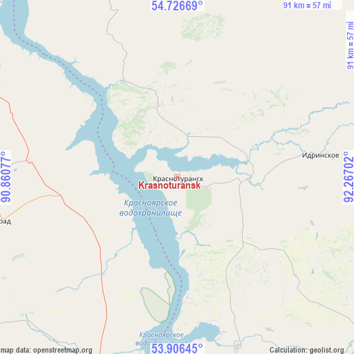
Krasnoturansk GPS coordinates[2]
54° 19' 6.996" North, 91° 33' 50.004" East
| Map corner | latitude | longitude |
|---|---|---|
| Upper-left | 54.72669°, | 90.86077° |
| Center: | 54.31861°, | 91.56389° |
| Lower-right: | 53.90645°, | 92.26702° |
| Map W x H: | 91.2×91.2 km | = 56.7×56.7mi |
| max Lat: | 73.50819° ⇑52.7% North |
| Krasnoturansk: | 54.31861° |
| min Lat: | ⇓47.3% South 41.28413° |
| min Long | Krasnoturansk | max Long |
| -179.12198° | 91.56389° | 179.35046° |
| W 86.2%⇐ | ⇒13.8% E |
Elevation
Elevation of Krasnoturansk is 322 m = 1056 ft, and this is 119.4 m = 392 ft above average elevation for this country.
| Max E: |
2518 m = 8261 ft | 14.9% |
| Krasnoturansk | 322 m 1056 ft | |
| Avg. | 202.6 m = 665 ft | |
Min E: |
-28 m = -92 ft | 85.1% |
See also: Russia elevation on elevation.city.
Geographical zone
Krasnoturansk is located in North temperate zone (between Tropic of Cancer and the Arctic Circle). Distance of this North polar circle is 1361.5 km =846 mi to North.| Distance of | km | miles | from Krasnoturansk |
|---|---|---|---|
| North Pole | 3967.4 | 2465.2 | to North |
| Arctic Circle | 1361.5 | 846 | to North |
| Tropic Cancer | 3433.7 | 2133.6 | to South |
| Equator | 6039.7 | 3752.9 | to South |


Nearby cities:
15 places around Krasnoturansk: (largest is in red/bold)
• Abakan
67.6 km =42 mi,  187°
187°
• Belyy Yar
80.3 km =49.9 mi, 188°
• Bograd
48.4 km =30.1 mi,  258°
258°
• Chernogorsk
58 km =36 mi,  198°
198°
• Idrinskoye
37.5 km =23.3 mi,  81°
81°
• Kuragino
87.2 km =54.2 mi,  123°
123°
• Minusinsk
68.1 km =42.3 mi,  173°
173°
• Podsineye
72.6 km =45.1 mi,  181°
181°
• Sayansk
28.1 km =17.5 mi,  131°
131°
• Shira
106 km =65.9 mi,  280°
280°
• Sorsk
92.6 km =57.5 mi,  247°
247°
• Tuim
104.9 km =65.2 mi,  271°
271°
• Ust’-Abakan
54.8 km =34.1 mi, 191°
• Zelënyy Bor
77.6 km =48.2 mi, 177°
• Zhemchuzhnyy
93.3 km =58 mi, 282°
Sources, notices
• [Note1] Compared only with cities in Russia existing in our database
• [Src1] Map data: © OpenStreetMap contributors (CC-BY-SA)
• [Src2] Other city data from geonames.org with taken over terms of usage.
• [Src3] Geographical zone / Annual Mean Temperature by Robert A. Rohde @ Wikipedia
