Volchansk geodata
Volchansk (Sverdlovsk) is a populated place; located in Russia in Asia/Yekaterinburg (GMT+5) time zone. With population of 10,403 people, there are 1453 cities with bigger population in this country. Compared to other cities in Russia, 89.7% of cities are located further ↓South; 71.7% of cities are located further ←West and 79.2% of cities have lower elevation than Volchansk. Note1


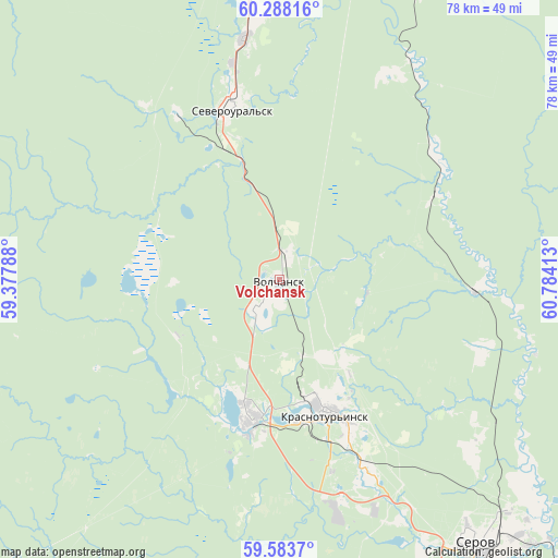
Volchansk GPS coordinates[2]
59° 56' 16.08" North, 60° 4' 51.6" East
| Map corner | latitude | longitude |
|---|---|---|
| Upper-left | 60.28816°, | 59.37788° |
| Center: | 59.9378°, | 60.081° |
| Lower-right: | 59.5837°, | 60.78413° |
| Map W x H: | 78.3×78.3 km | = 48.7×48.7mi |
| max Lat: | 73.50819° ⇑10.3% North |
| Volchansk: | 59.9378° |
| min Lat: | ⇓89.7% South 41.28413° |
| min Long | Volchansk | max Long |
| -179.12198° | 60.081° | 179.35046° |
| W 71.7%⇐ | ⇒28.3% E |
Elevation
Elevation of Volchansk is 241 m = 791 ft, and this is 38.4 m = 126 ft above average elevation for this country.
| Max E: |
2518 m = 8261 ft | 20.8% |
| Volchansk | 241 m 791 ft | |
| Avg. | 202.6 m = 665 ft | |
Min E: |
-28 m = -92 ft | 79.2% |
See also: Russia elevation on elevation.city.
Geographical zone
Volchansk is located in North temperate zone (between Tropic of Cancer and the Arctic Circle). Distance of this North polar circle is 736.7 km =457.8 mi to North.| Distance of | km | miles | from Volchansk |
|---|---|---|---|
| North Pole | 3342.6 | 2077 | to North |
| Arctic Circle | 736.7 | 457.8 | to North |
| Tropic Cancer | 4058.5 | 2521.8 | to South |
| Equator | 6664.5 | 4141.1 | to South |


Nearby cities:
15 places around Volchansk: (largest is in red/bold)
• Cherëmukhovo
46 km =28.6 mi,  353°
353°
• Ivdel’
85.8 km =53.3 mi,  12°
12°
• Karpinsk
19.2 km =11.9 mi,  194°
194°
• Krasnotur’insk
20.3 km =12.6 mi,  159°
159°
• Kytlym
69.3 km =43.1 mi,  225°
225°
• Lobva
87.2 km =54.2 mi, 163°
• Novaya Lyalya
102.4 km =63.6 mi, 163°
• Pavda
83.3 km =51.8 mi,  202°
202°
• Polunochnoye
105.2 km =65.4 mi, 10°
• Rudnichnyy
28.7 km =17.8 mi, 156°
• Serov
46.5 km =28.9 mi,  143°
143°
• Severoural’sk
25 km =15.5 mi,  343°
343°
• Tretiy Severnyy
30.8 km =19.1 mi, 347°
• Verkhotur’ye
126.4 km =78.5 mi, 161°
• Vorontsovka
32.3 km =20.1 mi, 164°
Sources, notices
• [Note1] Compared only with cities in Russia existing in our database
• [Src1] Map data: © OpenStreetMap contributors (CC-BY-SA)
• [Src2] Other city data from geonames.org with taken over terms of usage.
• [Src3] Geographical zone / Annual Mean Temperature by Robert A. Rohde @ Wikipedia
