Troitsk geodata
Troitsk (Omsk) is a populated place; located in Russia in Asia/Omsk (GMT+6) time zone. With population of 3,911 people, there are 3165 cities with bigger population in this country. Compared to other cities in Russia, 61.7% of cities are located further ↓South; 77.4% of cities are located further ←West and 63% of cities have higher elevation than Troitsk. Note1


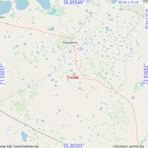
Troitsk GPS coordinates[2]
55° 42' 4.608" North, 72° 14' 1.284" East
| Map corner | latitude | longitude |
|---|---|---|
| Upper-left | 56.09549°, | 71.53057° |
| Center: | 55.70128°, | 72.23369° |
| Lower-right: | 55.30305°, | 72.93682° |
| Map W x H: | 88.1×88.1 km | = 54.7×54.7mi |
| max Lat: | 73.50819° ⇑38.3% North |
| Troitsk: | 55.70128° |
| min Lat: | ⇓61.7% South 41.28413° |
| min Long | Troitsk | max Long |
| -179.12198° | 72.23369° | 179.35046° |
| W 77.4%⇐ | ⇒22.6% E |
Elevation
Elevation of Troitsk is 118 m = 387 ft, and this is 84.6 m = 278 ft below average elevation for this country.
| Max E: |
2518 m = 8261 ft | 63% |
| Avg. | 202.6 m = 665 ft | |
| Troitsk | 118 m = 387 ft | |
Min E: |
-28 m = -92 ft | 37% |
See also: Russia elevation on elevation.city.
Geographical zone
Troitsk is located in North temperate zone (between Tropic of Cancer and the Arctic Circle). Distance of this North polar circle is 1207.8 km =750.5 mi to North.| Distance of | km | miles | from Troitsk |
|---|---|---|---|
| North Pole | 3813.7 | 2369.7 | to North |
| Arctic Circle | 1207.8 | 750.5 | to North |
| Tropic Cancer | 3587.5 | 2229.2 | to South |
| Equator | 6193.4 | 3848.4 | to South |


Nearby cities:
15 places around Troitsk: (largest is in red/bold)
• Beregovoy
85.6 km =53.2 mi,  133°
133°
• Krasnoyarka
69 km =42.9 mi, 126°
• Krasnyy Yar
67.1 km =41.7 mi,  139°
139°
• Krutaya Gorka
72.6 km =45.1 mi,  120°
120°
• Krutinka
56.4 km =35 mi,  306°
306°
• Luzino
97.9 km =60.8 mi,  148°
148°
• Lyubinskiy
67.4 km =41.9 mi, 154°
• Nazyvayevsk
57.2 km =35.5 mi,  255°
255°
• Novoomskiy
117.1 km =72.8 mi, 144°
• Omsk
106.6 km =66.2 mi, 137°
• Rostovka
41.4 km =25.7 mi,  211°
211°
• Sargatskoye
79.9 km =49.6 mi,  97°
97°
• Sherbakul’
119.4 km =74.2 mi,  175°
175°
• Tyukalinsk
19.3 km =12 mi,  353°
353°
• Vkhodnoy
102.3 km =63.6 mi, 144°
Sources, notices
• [Note1] Compared only with cities in Russia existing in our database
• [Src1] Map data: © OpenStreetMap contributors (CC-BY-SA)
• [Src2] Other city data from geonames.org with taken over terms of usage.
• [Src3] Geographical zone / Annual Mean Temperature by Robert A. Rohde @ Wikipedia
