Beregovoy geodata
Beregovoy (Omsk) is a populated place; located in Russia in Asia/Omsk (GMT+6) time zone. With population of 7,961 people, there are 1811 cities with bigger population in this country. Compared to other cities in Russia, 55% of cities are located further ↓South; 77.7% of cities are located further ←West and 76.7% of cities have higher elevation than Beregovoy. Note1


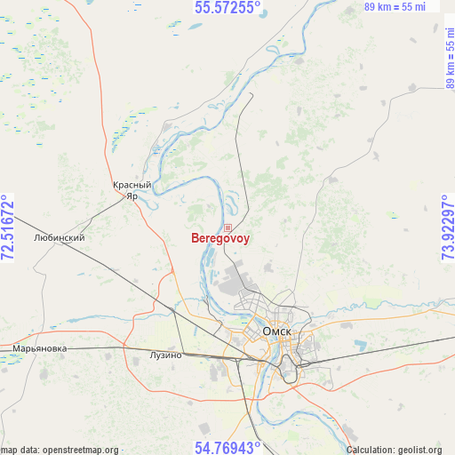
Beregovoy GPS coordinates[2]
55° 10' 22.836" North, 73° 13' 11.424" East
| Map corner | latitude | longitude |
|---|---|---|
| Upper-left | 55.57255°, | 72.51672° |
| Center: | 55.17301°, | 73.21984° |
| Lower-right: | 54.76943°, | 73.92297° |
| Map W x H: | 89.3×89.3 km | = 55.5×55.5mi |
| max Lat: | 73.50819° ⇑45% North |
| Beregovoy: | 55.17301° |
| min Lat: | ⇓55% South 41.28413° |
| min Long | Beregovoy | max Long |
| -179.12198° | 73.21984° | 179.35046° |
| W 77.7%⇐ | ⇒22.3% E |
Elevation
Elevation of Beregovoy is 82 m = 269 ft, and this is 120.6 m = 396 ft below average elevation for this country.
| Max E: |
2518 m = 8261 ft | 76.7% |
| Avg. | 202.6 m = 665 ft | |
| Beregovoy | 82 m = 269 ft | |
Min E: |
-28 m = -92 ft | 23.3% |
See also: Russia elevation on elevation.city.
Geographical zone
Beregovoy is located in North temperate zone (between Tropic of Cancer and the Arctic Circle). Distance of this North polar circle is 1266.5 km =787 mi to North.| Distance of | km | miles | from Beregovoy |
|---|---|---|---|
| North Pole | 3872.4 | 2406.2 | to North |
| Arctic Circle | 1266.5 | 787 | to North |
| Tropic Cancer | 3528.7 | 2192.6 | to South |
| Equator | 6134.7 | 3811.9 | to South |


Nearby cities:
15 places around Beregovoy: (largest is in red/bold)
• Azovo
54.1 km =33.6 mi,  193°
193°
• Irtyshskiy
46.3 km =28.8 mi,  149°
149°
• Kormilovka
59.3 km =36.8 mi,  108°
108°
• Krasnoyarka
19 km =11.8 mi,  339°
339°
• Krasnyy Yar
20.2 km =12.6 mi,  292°
292°
• Krutaya Gorka
21.3 km =13.2 mi,  0°
0°
• Luzino
27.6 km =17.1 mi,  205°
205°
• Lyubinskiy
33.6 km =20.9 mi,  266°
266°
• Novoomskiy
37.2 km =23.1 mi,  171°
171°
• Omsk
22.2 km =13.8 mi, 154°
• Sargatskoye
51.7 km =32.1 mi,  19°
19°
• Sherbakul’
80 km =49.7 mi,  221°
221°
• Tavricheskoye
70.7 km =43.9 mi,  157°
157°
• Troitsk
85.6 km =53.2 mi,  313°
313°
• Vkhodnoy
24.8 km =15.4 mi, 187°
Sources, notices
• [Note1] Compared only with cities in Russia existing in our database
• [Src1] Map data: © OpenStreetMap contributors (CC-BY-SA)
• [Src2] Other city data from geonames.org with taken over terms of usage.
• [Src3] Geographical zone / Annual Mean Temperature by Robert A. Rohde @ Wikipedia
