Omsk geodata
Omsk is a seat of a first-order administrative division; located in Russia in Asia/Omsk (GMT+6) time zone. With population of 1,129,281 people, there are 6 cities with bigger population in this country. Compared to other cities in Russia, 53.2% of cities are located further ↓South; 77.8% of cities are located further ←West and 74.4% of cities have higher elevation than Omsk. Note1


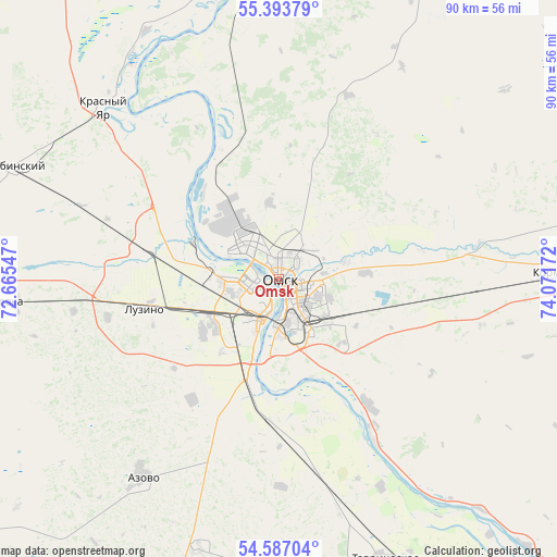
Omsk GPS coordinates[2]
54° 59' 32.784" North, 73° 22' 6.924" East
| Map corner | latitude | longitude |
|---|---|---|
| Upper-left | 55.39379°, | 72.66547° |
| Center: | 54.99244°, | 73.36859° |
| Lower-right: | 54.58704°, | 74.07172° |
| Map W x H: | 89.7×89.7 km | = 55.7×55.7mi |
| max Lat: | 73.50819° ⇑46.8% North |
| Omsk: | 54.99244° |
| min Lat: | ⇓53.2% South 41.28413° |
| min Long | Omsk | max Long |
| -179.12198° | 73.36859° | 179.35046° |
| W 77.8%⇐ | ⇒22.2% E |
Elevation
Elevation of Omsk is 90 m = 295 ft, and this is 112.6 m = 369 ft below average elevation for this country.
| Max E: |
2518 m = 8261 ft | 74.4% |
| Avg. | 202.6 m = 665 ft | |
| Omsk | 90 m = 295 ft | |
Min E: |
-28 m = -92 ft | 25.6% |
See also: Omsk elevation on elevation.city.
Geographical zone
Omsk is located in North temperate zone (between Tropic of Cancer and the Arctic Circle). Distance of this North polar circle is 1286.6 km =799.5 mi to North.| Distance of | km | miles | from Omsk |
|---|---|---|---|
| North Pole | 3892.5 | 2418.7 | to North |
| Arctic Circle | 1286.6 | 799.5 | to North |
| Tropic Cancer | 3508.7 | 2180.2 | to South |
| Equator | 6114.6 | 3799.4 | to South |


Nearby cities:
15 places around Omsk: (largest is in red/bold)
• Azovo
39.3 km =24.4 mi,  214°
214°
• Beregovoy
22.2 km =13.8 mi,  334°
334°
• Irtyshskiy
24.2 km =15 mi,  144°
144°
• Kalachinsk
77.2 km =48 mi,  85°
85°
• Kormilovka
46.8 km =29.1 mi, 88°
• Krasnoyarka
41.1 km =25.5 mi,  337°
337°
• Krasnyy Yar
39.5 km =24.5 mi,  314°
314°
• Krutaya Gorka
42.4 km =26.3 mi,  347°
347°
• Luzino
21.8 km =13.5 mi,  256°
256°
• Lyubinskiy
46.6 km =29 mi,  292°
292°
• Novoomskiy
17.3 km =10.7 mi,  194°
194°
• Sargatskoye
69.2 km =43 mi,  6°
6°
• Sherbakul’
74.1 km =46 mi,  237°
237°
• Tavricheskoye
48.5 km =30.1 mi,  159°
159°
• Vkhodnoy
13.4 km =8.3 mi,  250°
250°
Sources, notices
• [Note1] Compared only with cities in Russia existing in our database
• [Src1] Map data: © OpenStreetMap contributors (CC-BY-SA)
• [Src2] Other city data from geonames.org with taken over terms of usage.
• [Src3] Geographical zone / Annual Mean Temperature by Robert A. Rohde @ Wikipedia
