Sherbakul’ geodata
Sherbakul’ (Omsk) is a populated place; located in Russia in Asia/Omsk (GMT+6) time zone. With population of 7,251 people, there are 1946 cities with bigger population in this country. Compared to other cities in Russia, 50.1% of cities are located further ↑North; 77.4% of cities are located further ←West and 63.9% of cities have higher elevation than Sherbakul’. Note1


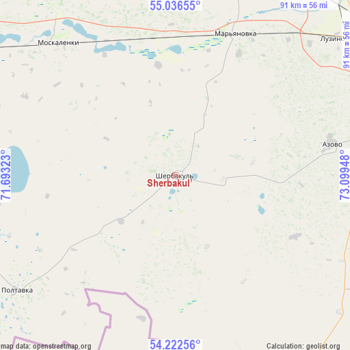
Sherbakul’ GPS coordinates[2]
54° 37' 53.724" North, 72° 23' 46.86" East
| Map corner | latitude | longitude |
|---|---|---|
| Upper-left | 55.03655°, | 71.69323° |
| Center: | 54.63159°, | 72.39635° |
| Lower-right: | 54.22256°, | 73.09948° |
| Map W x H: | 90.5×90.5 km | = 56.2×56.2mi |
| max Lat: | 73.50819° ⇑50.1% North |
| Sherbakul’: | 54.63159° |
| min Lat: | ⇓49.9% South 41.28413° |
| min Long | Sherbakul’ | max Long |
| -179.12198° | 72.39635° | 179.35046° |
| W 77.4%⇐ | ⇒22.6% E |
Elevation
Elevation of Sherbakul’ is 116 m = 381 ft, and this is 86.6 m = 284 ft below average elevation for this country.
| Max E: |
2518 m = 8261 ft | 63.9% |
| Avg. | 202.6 m = 665 ft | |
| Sherbakul’ | 116 m = 381 ft | |
Min E: |
-28 m = -92 ft | 36.1% |
See also: Russia elevation on elevation.city.
Geographical zone
Sherbakul’ is located in North temperate zone (between Tropic of Cancer and the Arctic Circle). Distance of this North polar circle is 1326.7 km =824.4 mi to North.| Distance of | km | miles | from Sherbakul’ |
|---|---|---|---|
| North Pole | 3932.6 | 2443.6 | to North |
| Arctic Circle | 1326.7 | 824.4 | to North |
| Tropic Cancer | 3468.5 | 2155.2 | to South |
| Equator | 6074.5 | 3774.5 | to South |


Nearby cities:
15 places around Sherbakul’: (largest is in red/bold)
• Azovo
41 km =25.5 mi,  79°
79°
• Beregovoy
80 km =49.7 mi,  41°
41°
• Irtyshskiy
79.1 km =49.2 mi, 75°
• Krasnoyarka
90.6 km =56.3 mi,  30°
30°
• Krasnyy Yar
75.9 km =47.2 mi, 26°
• Luzino
54 km =33.6 mi,  49°
49°
• Lyubinskiy
61.1 km =38 mi,  18°
18°
• Novoomskiy
62.6 km =38.9 mi,  68°
68°
• Odesskoye
59.2 km =36.8 mi,  141°
141°
• Omsk
74.1 km =46 mi,  57°
57°
• Pavlogradka
89.1 km =55.4 mi,  122°
122°
• Poltavka
50.4 km =31.3 mi,  234°
234°
• Rostovka
89.7 km =55.7 mi,  338°
338°
• Tavricheskoye
80.2 km =49.8 mi,  93°
93°
• Vkhodnoy
61.1 km =38 mi, 54°
Sources, notices
• [Note1] Compared only with cities in Russia existing in our database
• [Src1] Map data: © OpenStreetMap contributors (CC-BY-SA)
• [Src2] Other city data from geonames.org with taken over terms of usage.
• [Src3] Geographical zone / Annual Mean Temperature by Robert A. Rohde @ Wikipedia
