Tayga geodata
Tayga (Kemerovo Oblast) is a populated place; located in Russia in Asia/Novokuznetsk (GMT+7) time zone. With population of 24,328 people, there are 762 cities with bigger population in this country. Compared to other cities in Russia, 67.5% of cities are located further ↓South; 82.8% of cities are located further ←West and 81.1% of cities have lower elevation than Tayga. Note1


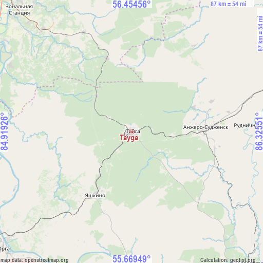
Tayga GPS coordinates[2]
56° 3' 50.472" North, 85° 37' 20.568" East
| Map corner | latitude | longitude |
|---|---|---|
| Upper-left | 56.45456°, | 84.91926° |
| Center: | 56.06402°, | 85.62238° |
| Lower-right: | 55.66949°, | 86.32551° |
| Map W x H: | 87.3×87.3 km | = 54.2×54.2mi |
| max Lat: | 73.50819° ⇑32.5% North |
| Tayga: | 56.06402° |
| min Lat: | ⇓67.5% South 41.28413° |
| min Long | Tayga | max Long |
| -179.12198° | 85.62238° | 179.35046° |
| W 82.8%⇐ | ⇒17.2% E |
Elevation
Elevation of Tayga is 261 m = 856 ft, and this is 58.4 m = 192 ft above average elevation for this country.
| Max E: |
2518 m = 8261 ft | 18.9% |
| Tayga | 261 m 856 ft | |
| Avg. | 202.6 m = 665 ft | |
Min E: |
-28 m = -92 ft | 81.1% |
See also: Russia elevation on elevation.city.
Geographical zone
Tayga is located in North temperate zone (between Tropic of Cancer and the Arctic Circle). Distance of this North polar circle is 1167.4 km =725.4 mi to North.| Distance of | km | miles | from Tayga |
|---|---|---|---|
| North Pole | 3773.3 | 2344.6 | to North |
| Arctic Circle | 1167.4 | 725.4 | to North |
| Tropic Cancer | 3627.8 | 2254.2 | to South |
| Equator | 6233.7 | 3873.4 | to South |


Nearby cities:
15 places around Tayga: (largest is in red/bold)
• Anzhero-Sudzhensk
25.3 km =15.7 mi,  85°
85°
• Barzas
57.4 km =35.7 mi,  130°
130°
• Berëzovskiy
63 km =39.1 mi,  145°
145°
• Bogashevo
44.9 km =27.9 mi,  318°
318°
• Izhmorskiy
64.8 km =40.3 mi,  77°
77°
• Kaltay
51.9 km =32.2 mi,  297°
297°
• Kedrovka
64.8 km =40.3 mi,  155°
155°
• Promyshlennovskiy
74 km =46 mi, 150°
• Rudnichnyy
39 km =24.2 mi, 86°
• Seversk
74.9 km =46.5 mi, 322°
• Timiryazevskoye
66 km =41 mi, 315°
• Tomsk
62.7 km =39 mi, 320°
• Yashkino
24.4 km =15.2 mi,  209°
209°
• Yaya
53.1 km =33 mi,  72°
72°
• Yurga
59.5 km =37 mi,  230°
230°
Sources, notices
• [Note1] Compared only with cities in Russia existing in our database
• [Src1] Map data: © OpenStreetMap contributors (CC-BY-SA)
• [Src2] Other city data from geonames.org with taken over terms of usage.
• [Src3] Geographical zone / Annual Mean Temperature by Robert A. Rohde @ Wikipedia
