Kaltay geodata
Kaltay (Tomsk Oblast) is a populated place; located in Russia in Asia/Tomsk (GMT+7) time zone. With population of 1,077 people, there are 4595 cities with bigger population in this country. Compared to other cities in Russia, 70.3% of cities are located further ↓South; 82% of cities are located further ←West and 65.7% of cities have higher elevation than Kaltay. Note1


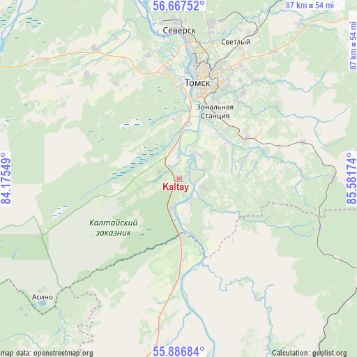
Kaltay GPS coordinates[2]
56° 16' 45.012" North, 84° 52' 42.996" East
| Map corner | latitude | longitude |
|---|---|---|
| Upper-left | 56.66752°, | 84.17549° |
| Center: | 56.27917°, | 84.87861° |
| Lower-right: | 55.88684°, | 85.58174° |
| Map W x H: | 86.8×86.8 km | = 53.9×53.9mi |
| max Lat: | 73.50819° ⇑29.7% North |
| Kaltay: | 56.27917° |
| min Lat: | ⇓70.3% South 41.28413° |
| min Long | Kaltay | max Long |
| -179.12198° | 84.87861° | 179.35046° |
| W 82%⇐ | ⇒18% E |
Elevation
Elevation of Kaltay is 112 m = 367 ft, and this is 90.6 m = 297 ft below average elevation for this country.
| Max E: |
2518 m = 8261 ft | 65.7% |
| Avg. | 202.6 m = 665 ft | |
| Kaltay | 112 m = 367 ft | |
Min E: |
-28 m = -92 ft | 34.3% |
See also: Russia elevation on elevation.city.
Geographical zone
Kaltay is located in North temperate zone (between Tropic of Cancer and the Arctic Circle). Distance of this North polar circle is 1143.5 km =710.5 mi to North.| Distance of | km | miles | from Kaltay |
|---|---|---|---|
| North Pole | 3749.4 | 2329.8 | to North |
| Arctic Circle | 1143.5 | 710.5 | to North |
| Tropic Cancer | 3651.7 | 2269.1 | to South |
| Equator | 6257.7 | 3888.4 | to South |


Nearby cities:
15 places around Kaltay: (largest is in red/bold)
• Aleksandrovskoye
60.2 km =37.4 mi,  31°
31°
• Anzhero-Sudzhensk
74.5 km =46.3 mi,  107°
107°
• Bogashevo
19.1 km =11.9 mi,  58°
58°
• Bolotnoye
73.9 km =45.9 mi,  203°
203°
• Kozhevnikovo
56.1 km =34.9 mi,  267°
267°
• Mel’nikovo
57.9 km =36 mi,  302°
302°
• Moryakovskiy Zaton
48.2 km =30 mi,  343°
343°
• Rudnichnyy
87.6 km =54.4 mi,  104°
104°
• Samus’
52.9 km =32.9 mi,  348°
348°
• Seversk
35.7 km =22.2 mi,  0°
0°
• Tayga
51.9 km =32.2 mi,  117°
117°
• Timiryazevskoye
23.4 km =14.5 mi,  359°
359°
• Tomsk
25 km =15.5 mi,  13°
13°
• Yashkino
56.5 km =35.1 mi,  142°
142°
• Yurga
61.8 km =38.4 mi,  179°
179°
Sources, notices
• [Note1] Compared only with cities in Russia existing in our database
• [Src1] Map data: © OpenStreetMap contributors (CC-BY-SA)
• [Src2] Other city data from geonames.org with taken over terms of usage.
• [Src3] Geographical zone / Annual Mean Temperature by Robert A. Rohde @ Wikipedia
