Yashkino geodata
Yashkino (Kemerovo Oblast) is a populated place; located in Russia in Asia/Novokuznetsk (GMT+7) time zone. With population of 15,197 people, there are 1084 cities with bigger population in this country. Compared to other cities in Russia, 64.8% of cities are located further ↓South; 82.6% of cities are located further ←West and 80.9% of cities have lower elevation than Yashkino. Note1


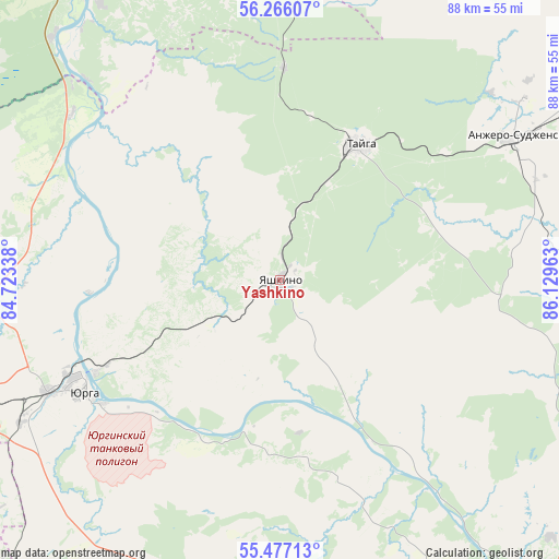
Yashkino GPS coordinates[2]
55° 52' 24.96" North, 85° 25' 35.4" East
| Map corner | latitude | longitude |
|---|---|---|
| Upper-left | 56.26607°, | 84.72338° |
| Center: | 55.8736°, | 85.4265° |
| Lower-right: | 55.47713°, | 86.12963° |
| Map W x H: | 87.7×87.7 km | = 54.5×54.5mi |
| max Lat: | 73.50819° ⇑35.2% North |
| Yashkino: | 55.8736° |
| min Lat: | ⇓64.8% South 41.28413° |
| min Long | Yashkino | max Long |
| -179.12198° | 85.4265° | 179.35046° |
| W 82.6%⇐ | ⇒17.4% E |
Elevation
Elevation of Yashkino is 256 m = 840 ft, and this is 53.4 m = 175 ft above average elevation for this country.
| Max E: |
2518 m = 8261 ft | 19.1% |
| Yashkino | 256 m 840 ft | |
| Avg. | 202.6 m = 665 ft | |
Min E: |
-28 m = -92 ft | 80.9% |
See also: Russia elevation on elevation.city.
Geographical zone
Yashkino is located in North temperate zone (between Tropic of Cancer and the Arctic Circle). Distance of this North polar circle is 1188.6 km =738.6 mi to North.| Distance of | km | miles | from Yashkino |
|---|---|---|---|
| North Pole | 3794.5 | 2357.8 | to North |
| Arctic Circle | 1188.6 | 738.6 | to North |
| Tropic Cancer | 3606.6 | 2241 | to South |
| Equator | 6212.6 | 3860.3 | to South |


Nearby cities:
15 places around Yashkino: (largest is in red/bold)
• Anzhero-Sudzhensk
44 km =27.3 mi,  58°
58°
• Barzas
58.2 km =36.2 mi,  106°
106°
• Berëzovskiy
57.2 km =35.5 mi,  122°
122°
• Bogashevo
57.7 km =35.9 mi,  342°
342°
• Bolotnoye
68.1 km =42.3 mi,  250°
250°
• Borovoy
64 km =39.8 mi,  139°
139°
• Kaltay
56.5 km =35.1 mi,  322°
322°
• Kedrovka
54.4 km =33.8 mi,  134°
134°
• Kemerovo
72.9 km =45.3 mi,  145°
145°
• Pioner
70.1 km =43.6 mi, 151°
• Promyshlennovskiy
65.1 km =40.5 mi, 131°
• Rudnichnyy
56.3 km =35 mi,  65°
65°
• Tayga
24.4 km =15.2 mi,  29°
29°
• Topki
67.4 km =41.9 mi,  169°
169°
• Yurga
37.7 km =23.4 mi,  243°
243°
Sources, notices
• [Note1] Compared only with cities in Russia existing in our database
• [Src1] Map data: © OpenStreetMap contributors (CC-BY-SA)
• [Src2] Other city data from geonames.org with taken over terms of usage.
• [Src3] Geographical zone / Annual Mean Temperature by Robert A. Rohde @ Wikipedia
