Tomsk geodata
Tomsk (Tomsk Oblast) is a seat of a first-order administrative division; located in Russia in Asia/Tomsk (GMT+7) time zone. With population of 485,519 people, there are 36 cities with bigger population in this country. Compared to other cities in Russia, 72.6% of cities are located further ↓South; 82.2% of cities are located further ←West and 63.5% of cities have higher elevation than Tomsk. Note1


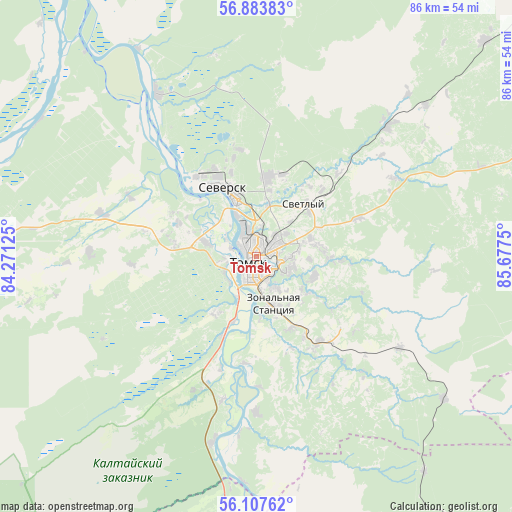
Tomsk GPS coordinates[2]
56° 29' 51.756" North, 84° 58' 27.732" East
| Map corner | latitude | longitude |
|---|---|---|
| Upper-left | 56.88383°, | 84.27125° |
| Center: | 56.49771°, | 84.97437° |
| Lower-right: | 56.10762°, | 85.6775° |
| Map W x H: | 86.3×86.3 km | = 53.6×53.6mi |
| max Lat: | 73.50819° ⇑27.4% North |
| Tomsk: | 56.49771° |
| min Lat: | ⇓72.6% South 41.28413° |
| min Long | Tomsk | max Long |
| -179.12198° | 84.97437° | 179.35046° |
| W 82.2%⇐ | ⇒17.8% E |
Elevation
Elevation of Tomsk is 117 m = 384 ft, and this is 85.6 m = 281 ft below average elevation for this country.
| Max E: |
2518 m = 8261 ft | 63.5% |
| Avg. | 202.6 m = 665 ft | |
| Tomsk | 117 m = 384 ft | |
Min E: |
-28 m = -92 ft | 36.5% |
See also: Tomsk elevation on elevation.city.
Geographical zone
Tomsk is located in North temperate zone (between Tropic of Cancer and the Arctic Circle). Distance of this North polar circle is 1119.2 km =695.4 mi to North.| Distance of | km | miles | from Tomsk |
|---|---|---|---|
| North Pole | 3725.1 | 2314.7 | to North |
| Arctic Circle | 1119.2 | 695.4 | to North |
| Tropic Cancer | 3676 | 2284.2 | to South |
| Equator | 6282 | 3903.5 | to South |


Nearby cities:
15 places around Tomsk: (largest is in red/bold)
• Aleksandrovskoye
37.1 km =23.1 mi,  43°
43°
• Anzhero-Sudzhensk
79.9 km =49.6 mi,  125°
125°
• Bogashevo
17.8 km =11.1 mi,  144°
144°
• Kaltay
25 km =15.5 mi,  193°
193°
• Kozhevnikovo
67.2 km =41.8 mi,  246°
246°
• Krasnyy Yar
75.1 km =46.7 mi,  338°
338°
• Mel’nikovo
55 km =34.2 mi,  276°
276°
• Moryakovskiy Zaton
29.5 km =18.3 mi,  317°
317°
• Samus’
32.1 km =19.9 mi,  328°
328°
• Seversk
12.6 km =7.8 mi, 334°
• Svetlyy
76.4 km =47.5 mi,  52°
52°
• Tayga
62.7 km =39 mi, 140°
• Timiryazevskoye
6 km =3.7 mi,  261°
261°
• Yashkino
74.8 km =46.5 mi,  158°
158°
• Yurga
86.3 km =53.6 mi,  183°
183°
Sources, notices
• [Note1] Compared only with cities in Russia existing in our database
• [Src1] Map data: © OpenStreetMap contributors (CC-BY-SA)
• [Src2] Other city data from geonames.org with taken over terms of usage.
• [Src3] Geographical zone / Annual Mean Temperature by Robert A. Rohde @ Wikipedia
