Kuzedeyevo geodata
Kuzedeyevo (Kemerovo Oblast) is a populated place; located in Russia in Asia/Novokuznetsk (GMT+7) time zone. With population of 3,448 people, there are 3438 cities with bigger population in this country. Compared to other cities in Russia, 60% of cities are located further ↑North; 84.6% of cities are located further ←West and 77.8% of cities have lower elevation than Kuzedeyevo. Note1


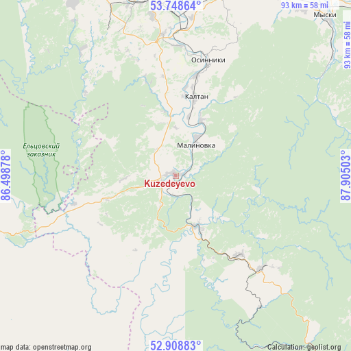
Kuzedeyevo GPS coordinates[2]
53° 19' 50.88" North, 87° 12' 6.84" East
| Map corner | latitude | longitude |
|---|---|---|
| Upper-left | 53.74864°, | 86.49878° |
| Center: | 53.3308°, | 87.2019° |
| Lower-right: | 52.90883°, | 87.90503° |
| Map W x H: | 93.4×93.4 km | = 58×58mi |
| max Lat: | 73.50819° ⇑60% North |
| Kuzedeyevo: | 53.3308° |
| min Lat: | ⇓40% South 41.28413° |
| min Long | Kuzedeyevo | max Long |
| -179.12198° | 87.2019° | 179.35046° |
| W 84.6%⇐ | ⇒15.4% E |
Elevation
Elevation of Kuzedeyevo is 232 m = 761 ft, and this is 29.4 m = 96 ft above average elevation for this country.
| Max E: |
2518 m = 8261 ft | 22.2% |
| Kuzedeyevo | 232 m 761 ft | |
| Avg. | 202.6 m = 665 ft | |
Min E: |
-28 m = -92 ft | 77.8% |
See also: Russia elevation on elevation.city.
Geographical zone
Kuzedeyevo is located in North temperate zone (between Tropic of Cancer and the Arctic Circle). Distance of this North polar circle is 1471.3 km =914.2 mi to North.| Distance of | km | miles | from Kuzedeyevo |
|---|---|---|---|
| North Pole | 4077.2 | 2533.5 | to North |
| Arctic Circle | 1471.3 | 914.2 | to North |
| Tropic Cancer | 3323.9 | 2065.4 | to South |
| Equator | 5929.8 | 3684.6 | to South |


Nearby cities:
15 places around Kuzedeyevo: (largest is in red/bold)
• Abagur
44.6 km =27.7 mi,  4°
4°
• Chugunash
63.9 km =39.7 mi,  142°
142°
• Kaltan
22.9 km =14.2 mi,  7°
7°
• Kaz
47.2 km =29.3 mi,  171°
171°
• Listvyagi
41.9 km =26 mi,  336°
336°
• Mundybash
14.8 km =9.2 mi,  154°
154°
• Myski
57.8 km =35.9 mi,  43°
43°
• Novokuznetsk
47.6 km =29.6 mi,  352°
352°
• Osinniki
34.2 km =21.3 mi,  17°
17°
• Pritomskiy
56 km =34.8 mi,  28°
28°
• Pushtulim
53.4 km =33.2 mi,  254°
254°
• Sheregesh
69.4 km =43.1 mi,  131°
131°
• Sosnovka
37.6 km =23.4 mi,  355°
355°
• Tayzhina
40.6 km =25.2 mi, 22°
• Temirtau
27.2 km =16.9 mi, 142°
Sources, notices
• [Note1] Compared only with cities in Russia existing in our database
• [Src1] Map data: © OpenStreetMap contributors (CC-BY-SA)
• [Src2] Other city data from geonames.org with taken over terms of usage.
• [Src3] Geographical zone / Annual Mean Temperature by Robert A. Rohde @ Wikipedia
