Mundybash geodata
Mundybash (Kemerovo Oblast) is a populated place; located in Russia in Asia/Novokuznetsk (GMT+7) time zone. With population of 5,870 people, there are 2307 cities with bigger population in this country. Compared to other cities in Russia, 61.3% of cities are located further ↑North; 84.7% of cities are located further ←West and 83.1% of cities have lower elevation than Mundybash. Note1


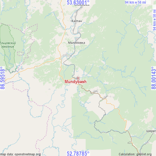
Mundybash GPS coordinates[2]
53° 12' 39.6" North, 87° 17' 53.88" East
| Map corner | latitude | longitude |
|---|---|---|
| Upper-left | 53.63001°, | 86.59518° |
| Center: | 53.211°, | 87.2983° |
| Lower-right: | 52.78785°, | 88.00143° |
| Map W x H: | 93.6×93.6 km | = 58.2×58.2mi |
| max Lat: | 73.50819° ⇑61.3% North |
| Mundybash: | 53.211° |
| min Lat: | ⇓38.7% South 41.28413° |
| min Long | Mundybash | max Long |
| -179.12198° | 87.2983° | 179.35046° |
| W 84.7%⇐ | ⇒15.3% E |
Elevation
Elevation of Mundybash is 288 m = 945 ft, and this is 85.4 m = 280 ft above average elevation for this country.
| Max E: |
2518 m = 8261 ft | 16.9% |
| Mundybash | 288 m 945 ft | |
| Avg. | 202.6 m = 665 ft | |
Min E: |
-28 m = -92 ft | 83.1% |
See also: Russia elevation on elevation.city.
Geographical zone
Mundybash is located in North temperate zone (between Tropic of Cancer and the Arctic Circle). Distance of this North polar circle is 1484.7 km =922.5 mi to North.| Distance of | km | miles | from Mundybash |
|---|---|---|---|
| North Pole | 4090.6 | 2541.8 | to North |
| Arctic Circle | 1484.7 | 922.5 | to North |
| Tropic Cancer | 3310.6 | 2057.1 | to South |
| Equator | 5916.5 | 3676.3 | to South |


Nearby cities:
15 places around Mundybash: (largest is in red/bold)
• Abagur
57.9 km =36 mi,  357°
357°
• Chugunash
49.6 km =30.8 mi,  139°
139°
• Kaltan
36.2 km =22.5 mi,  354°
354°
• Kaz
33.3 km =20.7 mi,  178°
178°
• Kuzedeyevo
14.8 km =9.2 mi,  334°
334°
• Listvyagi
56.7 km =35.2 mi,  336°
336°
• Novokuznetsk
61.8 km =38.4 mi, 348°
• Osinniki
46.1 km =28.6 mi,  5°
5°
• Pushtulim
58 km =36 mi,  269°
269°
• Sheregesh
56.2 km =34.9 mi,  125°
125°
• Sosnovka
51.7 km =32.1 mi, 349°
• Spassk
60 km =37.3 mi,  149°
149°
• Tashtagol
63.4 km =39.4 mi, 141°
• Tayzhina
51.6 km =32.1 mi, 10°
• Temirtau
13.2 km =8.2 mi, 128°
Sources, notices
• [Note1] Compared only with cities in Russia existing in our database
• [Src1] Map data: © OpenStreetMap contributors (CC-BY-SA)
• [Src2] Other city data from geonames.org with taken over terms of usage.
• [Src3] Geographical zone / Annual Mean Temperature by Robert A. Rohde @ Wikipedia
